Val Vomano geodata
Val Vomano (Abruzzo) is a populated place; located in Italy in Europe/Rome (GMT+2) time zone. With population of 939 people, there are 6928 cities with bigger population in this country. Compared to other cities in Italy, 65.7% of cities are located further ↑North; 76.2% of cities are located further ←West and 61.8% of cities have higher elevation than Val Vomano. Note1
Administrative division(s):
- Level 1: Abruzzo
- Level 2: Provincia di Teramo
- Level 3: Penna Sant'Andrea


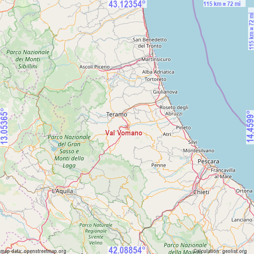
Val Vomano GPS coordinates[2]
42° 36' 29.484" North, 13° 45' 24.372" East
| Map corner | latitude | longitude |
|---|---|---|
| Upper-left | 43.12354°, | 13.05365° |
| Center: | 42.60819°, | 13.75677° |
| Lower-right: | 42.08854°, | 14.4599° |
| Map W x H: | 115.1×115.1 km | = 71.5×71.5mi |
| max Lat: | 47.04031° ⇑65.7% North |
| Val Vomano: | 42.60819° |
| min Lat: | ⇓34.3% South 35.50142° |
| min Long | Val Vomano | max Long |
| 6.69888° | 13.75677° | 18.48682° |
| W 76.2%⇐ | ⇒23.8% E |
Elevation
Elevation of Val Vomano is 150 m = 492 ft, and this is 156.7 m = 514 ft below average elevation for this country.
| Max E: |
2085 m = 6841 ft | 61.8% |
| Avg. | 306.7 m = 1006 ft | |
| Val Vomano | 150 m = 492 ft | |
Min E: |
-4 m = -13 ft | 38.2% |
See also: Italy elevation on elevation.city.
Geographical zone
Val Vomano is located in North temperate zone (between Tropic of Cancer and the Arctic Circle). Distance of this Northern Tropic circle is 2131.7 km =1324.6 mi to South.| Distance of | km | miles | from Val Vomano |
|---|---|---|---|
| North Pole | 5269.5 | 3274.3 | to North |
| Arctic Circle | 2663.6 | 1655.1 | to North |
| Tropic Cancer | 2131.7 | 1324.6 | to South |
| Equator | 4737.6 | 2943.8 | to South |


Nearby cities:
15 places around Val Vomano: (largest is in red/bold)
• Basciano
2.2 km =1.4 mi,  232°
232°
• Bisenti
9.5 km =5.9 mi,  158°
158°
• Canzano
5.7 km =3.5 mi,  42°
42°
• Castel Castagna
8 km =5 mi,  204°
204°
• Castellalto
9.3 km =5.8 mi,  34°
34°
• Castelnuovo Vomano
8 km =5 mi,  72°
72°
• Cellino Attanasio
8.8 km =5.5 mi,  106°
106°
• Cermignano
3.7 km =2.3 mi,  120°
120°
• Colleatterrato Alto
8.3 km =5.2 mi,  344°
344°
• Nepezzano
9.1 km =5.7 mi,  359°
359°
• Penna Sant'Andrea
2 km =1.2 mi,  141°
141°
• Piano d'Accio
8.4 km =5.2 mi,  0°
0°
• Teramo
7.6 km =4.7 mi,  321°
321°
• Tordinia-Villa Ripa
8.6 km =5.3 mi,  288°
288°
• Villa Vomano
0.8 km =0.5 mi,  45°
45°
Sources, notices
• [Note1] Compared only with cities in Italy existing in our database
• [Src1] Map data: © OpenStreetMap contributors (CC-BY-SA)
• [Src2] Other city data from geonames.org with taken over terms of usage.
• [Src3] Geographical zone / Annual Mean Temperature by Robert A. Rohde @ Wikipedia
