Basciano geodata
Basciano (Abruzzo) is a seat of a third-order administrative division; located in Italy in Europe/Rome (GMT+2) time zone. With population of 688 people, there are 8379 cities with bigger population in this country. Compared to other cities in Italy, 65.7% of cities are located further ↑North; 76% of cities are located further ←West and 62.5% of cities have lower elevation than Basciano. Note1


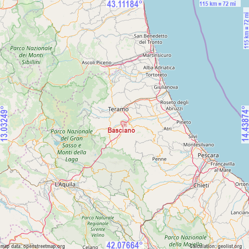
Basciano GPS coordinates[2]
42° 35' 47.004" North, 13° 44' 8.196" East
| Map corner | latitude | longitude |
|---|---|---|
| Upper-left | 43.11184°, | 13.03249° |
| Center: | 42.59639°, | 13.73561° |
| Lower-right: | 42.07664°, | 14.43874° |
| Map W x H: | 115.1×115.1 km | = 71.5×71.5mi |
| max Lat: | 47.04031° ⇑65.7% North |
| Basciano: | 42.59639° |
| min Lat: | ⇓34.3% South 35.50142° |
| min Long | Basciano | max Long |
| 6.69888° | 13.73561° | 18.48682° |
| W 76%⇐ | ⇒24% E |
Elevation
Elevation of Basciano is 319 m = 1047 ft, and this is 12.3 m = 40 ft above average elevation for this country.
| Max E: |
2085 m = 6841 ft | 37.5% |
| Basciano | 319 m 1047 ft | |
| Avg. | 306.7 m = 1006 ft | |
Min E: |
-4 m = -13 ft | 62.5% |
See also: Italy elevation on elevation.city.
Geographical zone
Basciano is located in North temperate zone (between Tropic of Cancer and the Arctic Circle). Distance of this Northern Tropic circle is 2130.4 km =1323.8 mi to South.| Distance of | km | miles | from Basciano |
|---|---|---|---|
| North Pole | 5270.8 | 3275.1 | to North |
| Arctic Circle | 2664.9 | 1655.9 | to North |
| Tropic Cancer | 2130.4 | 1323.8 | to South |
| Equator | 4736.3 | 2943 | to South |


Nearby cities:
15 places around Basciano: (largest is in red/bold)
• Bisenti
9.2 km =5.7 mi,  145°
145°
• Canzano
7.8 km =4.8 mi,  45°
45°
• Castel Castagna
6.1 km =3.8 mi,  194°
194°
• Cermignano
4.9 km =3 mi,  96°
96°
• Colleatterrato Alto
9.3 km =5.8 mi,  357°
357°
• Colledara
8 km =5 mi,  217°
217°
• Montorio al Vomano
8.2 km =5.1 mi,  258°
258°
• Penna Sant'Andrea
3 km =1.9 mi, 95°
• Piano d'Accio
9.9 km =6.2 mi,  10°
10°
• Teramo
7.8 km =4.8 mi,  337°
337°
• Tordinia-Villa Ripa
7.6 km =4.7 mi,  302°
302°
• Torricella
9.5 km =5.9 mi,  317°
317°
• Tossicia
9.3 km =5.8 mi,  231°
231°
• Val Vomano
2.2 km =1.4 mi, 52°
• Villa Vomano
3 km =1.9 mi, 50°
Sources, notices
• [Note1] Compared only with cities in Italy existing in our database
• [Src1] Map data: © OpenStreetMap contributors (CC-BY-SA)
• [Src2] Other city data from geonames.org with taken over terms of usage.
• [Src3] Geographical zone / Annual Mean Temperature by Robert A. Rohde @ Wikipedia
