Al Qaţrānah geodata
Al Qaţrānah (Karak) is a seat of a second-order administrative division; located in Jordan in Asia/Amman (GMT+3) time zone. In our database, there are 84 cities with bigger population. Compared to other cities in Jordan, 81.2% of cities are located further ↑North; 82.6% of cities are located further ←West and 56.5% of cities have lower elevation than Al Qaţrānah. Note1


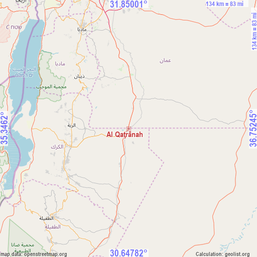
Al Qaţrānah GPS coordinates[2]
31° 15' 2.988" North, 36° 2' 57.552" East
| Map corner | latitude | longitude |
|---|---|---|
| Upper-left | 31.85001°, | 35.3462° |
| Center: | 31.25083°, | 36.04932° |
| Lower-right: | 30.64782°, | 36.75245° |
| Map W x H: | 133.7×133.7 km | = 83.1×83.1mi |
| max Lat: | 33.31405° ⇑81.2% North |
| Al Qaţrānah: | 31.25083° |
| min Lat: | ⇓18.8% South 29.40842° |
| min Long | Al Qaţrānah | max Long |
| 34.97918° | 36.04932° | 38.70342° |
| W 82.6%⇐ | ⇒17.4% E |
Elevation
Elevation of Al Qaţrānah is 773 m = 2536 ft, and this is 87.3 m = 286 ft above average elevation for this country.
| Max E: |
1440 m = 4724 ft | 43.5% |
| Al Qaţrānah | 773 m 2536 ft | |
| Avg. | 685.7 m = 2250 ft | |
Min E: |
-366 m = -1201 ft | 56.5% |
See also: Jordan elevation on elevation.city.
Geographical zone
Al Qaţrānah is located in North temperate zone (between Tropic of Cancer and the Arctic Circle). Distance of this Northern Tropic circle is 868.8 km =539.8 mi to South.| Distance of | km | miles | from Al Qaţrānah |
|---|---|---|---|
| North Pole | 6532.3 | 4059 | to North |
| Arctic Circle | 3926.4 | 2439.8 | to North |
| Tropic Cancer | 868.8 | 539.8 | to South |
| Equator | 3474.8 | 2159.1 | to South |


Nearby cities:
15 places around Al Qaţrānah: (largest is in red/bold)
• Adir
27.9 km =17.3 mi,  258°
258°
• Al Khinzīrah
47.7 km =29.6 mi,  242°
242°
• Al Mazār al Janūbī
39.4 km =24.5 mi, 238°
• Al Mughayyir
31.6 km =19.6 mi,  303°
303°
• Al Qaşr
29.9 km =18.6 mi,  283°
283°
• Al Ḩusaynīyah
39.9 km =24.8 mi,  231°
231°
• Ar Rabbah
29.6 km =18.4 mi,  273°
273°
• Dhībān
37.4 km =23.2 mi,  317°
317°
• Fuqū‘
35.5 km =22.1 mi,  291°
291°
• Karak City
29 km =18 mi,  250°
250°
• Mulayḩ
43.7 km =27.2 mi,  328°
328°
• Qīr Moāv
34.1 km =21.2 mi, 257°
• Umm ar Raşāş
31.6 km =19.6 mi,  336°
336°
• ‘Ayy
40.7 km =25.3 mi, 251°
• ‘Izrā
35.4 km =22 mi, 253°
Sources, notices
• [Note1] Compared only with cities in Jordan existing in our database
• [Src1] Map data: © OpenStreetMap contributors (CC-BY-SA)
• [Src2] Other city data from geonames.org with taken over terms of usage.
• [Src3] Geographical zone / Annual Mean Temperature by Robert A. Rohde @ Wikipedia
