Nagaoka geodata
Nagaoka (Niigata) is a seat of a second-order administrative division; located in Japan in Asia/Tokyo (GMT+9) time zone. With population of 195,318 people, there are 104 cities with bigger population in this country. Compared to other cities in Japan, 84% of cities are located further ↓South; 58.5% of cities are located further ←West and 55.4% of cities have higher elevation than Nagaoka. Note1


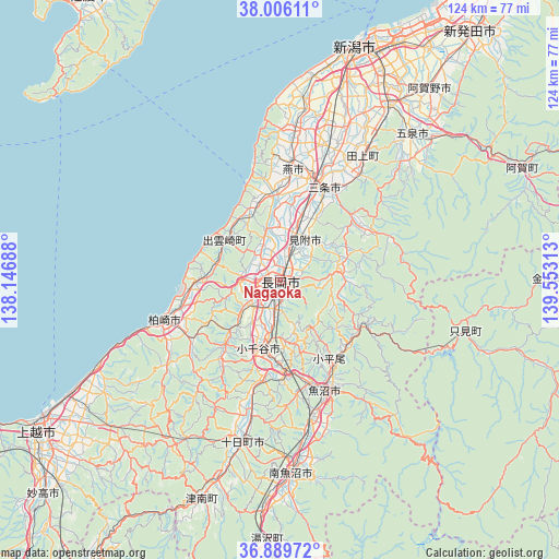
Nagaoka GPS coordinates[2]
37° 27' 0" North, 138° 51' 0" East
| Map corner | latitude | longitude |
|---|---|---|
| Upper-left | 38.00611°, | 138.14688° |
| Center: | 37.45°, | 138.85° |
| Lower-right: | 36.88972°, | 139.55313° |
| Map W x H: | 124.1×124.1 km | = 77.1×77.1mi |
| max Lat: | 45.40944° ⇑16% North |
| Nagaoka: | 37.45° |
| min Lat: | ⇓84% South 24.34478° |
| min Long | Nagaoka | max Long |
| 123° | 138.85° | 145.575° |
| W 58.5%⇐ | ⇒41.5% E |
Elevation
Elevation of Nagaoka is 23 m = 75 ft, and this is 61.6 m = 202 ft below average elevation for this country.
| Max E: |
1086 m = 3563 ft | 55.4% |
| Avg. | 84.6 m = 278 ft | |
| Nagaoka | 23 m = 75 ft | |
Min E: |
-2 m = -7 ft | 44.6% |
See also: Nagaoka elevation on elevation.city.
Geographical zone
Nagaoka is located in North temperate zone (between Tropic of Cancer and the Arctic Circle). Distance of this Northern Tropic circle is 1558.1 km =968.2 mi to South.| Distance of | km | miles | from Nagaoka |
|---|---|---|---|
| North Pole | 5843 | 3630.7 | to North |
| Arctic Circle | 3237.1 | 2011.4 | to North |
| Tropic Cancer | 1558.1 | 968.2 | to South |
| Equator | 4164 | 2587.4 | to South |


Nearby cities:
15 places around Nagaoka: (largest is in red/bold)
• Gosen
42.1 km =26.2 mi,  41°
41°
• Kamo
28.9 km =18 mi,  34°
34°
• Kashiwazaki
28.1 km =17.5 mi,  250°
250°
• Maki
33.5 km =20.8 mi,  5°
5°
• Minamiuonuma
40.9 km =25.4 mi,  177°
177°
• Mitsuke
11.8 km =7.3 mi, 38°
• Muramatsu
39.1 km =24.3 mi,  46°
46°
• Ojiya
17.3 km =10.7 mi,  194°
194°
• Sanjō
20.5 km =12.7 mi, 25°
• Shirone
38 km =23.6 mi,  23°
23°
• Tochio-honchō
13.1 km =8.1 mi,  77°
77°
• Tsubame
24.8 km =15.4 mi, 15°
• Tōkamachi
36 km =22.4 mi, 191°
• Uonuma
24.9 km =15.5 mi,  156°
156°
• Yoshida-kasugachō
26.1 km =16.2 mi, 6°
Sources, notices
• [Note1] Compared only with cities in Japan existing in our database
• [Src1] Map data: © OpenStreetMap contributors (CC-BY-SA)
• [Src2] Other city data from geonames.org with taken over terms of usage.
• [Src3] Geographical zone / Annual Mean Temperature by Robert A. Rohde @ Wikipedia
