Kashiwazaki geodata
Kashiwazaki (Niigata) is a seat of a second-order administrative division; located in Japan in Asia/Tokyo (GMT+9) time zone. With population of 86,183 people, there are 233 cities with bigger population in this country. Compared to other cities in Japan, 83.4% of cities are located further ↓South; 56.9% of cities are located further ←West and 93.5% of cities have higher elevation than Kashiwazaki. Note1


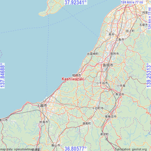
Kashiwazaki GPS coordinates[2]
37° 22' 0.012" North, 138° 33' 0" East
| Map corner | latitude | longitude |
|---|---|---|
| Upper-left | 37.92341°, | 137.84688° |
| Center: | 37.36667°, | 138.55° |
| Lower-right: | 36.80577°, | 139.25313° |
| Map W x H: | 124.3×124.3 km | = 77.2×77.2mi |
| max Lat: | 45.40944° ⇑16.6% North |
| Kashiwazaki: | 37.36667° |
| min Lat: | ⇓83.4% South 24.34478° |
| min Long | Kashiwazaki | max Long |
| 123° | 138.55° | 145.575° |
| W 56.9%⇐ | ⇒43.1% E |
Elevation
Elevation of Kashiwazaki is 4 m = 13 ft, and this is 80.6 m = 264 ft below average elevation for this country.
| Max E: |
1086 m = 3563 ft | 93.5% |
| Avg. | 84.6 m = 278 ft | |
| Kashiwazaki | 4 m = 13 ft | |
Min E: |
-2 m = -7 ft | 6.5% |
See also: Kashiwazaki elevation on elevation.city.
Geographical zone
Kashiwazaki is located in North temperate zone (between Tropic of Cancer and the Arctic Circle). Distance of this Northern Tropic circle is 1548.9 km =962.4 mi to South.| Distance of | km | miles | from Kashiwazaki |
|---|---|---|---|
| North Pole | 5852.3 | 3636.4 | to North |
| Arctic Circle | 3246.4 | 2017.2 | to North |
| Tropic Cancer | 1548.9 | 962.4 | to South |
| Equator | 4154.8 | 2581.7 | to South |


Nearby cities:
15 places around Kashiwazaki: (largest is in red/bold)
• Arai
49.8 km =30.9 mi,  215°
215°
• Jōetsu
36.9 km =22.9 mi,  228°
228°
• Minamiuonuma
42.7 km =26.5 mi,  137°
137°
• Mitsuke
38.6 km =24 mi,  61°
61°
• Muikamachi
44.5 km =27.7 mi, 138°
• Myoko
46.2 km =28.7 mi,  212°
212°
• Nagaoka
28.1 km =17.5 mi,  70°
70°
• Ojiya
23.3 km =14.5 mi,  108°
108°
• Sanjō
44.9 km =27.9 mi,  51°
51°
• Shiozawa
45.2 km =28.1 mi, 144°
• Tochio-honchō
41.2 km =25.6 mi, 72°
• Tsubame
46.8 km =29.1 mi,  44°
44°
• Tōkamachi
32.3 km =20.1 mi, 143°
• Uonuma
38.9 km =24.2 mi, 110°
• Yoshida-kasugachō
45.9 km =28.5 mi, 39°
Sources, notices
• [Note1] Compared only with cities in Japan existing in our database
• [Src1] Map data: © OpenStreetMap contributors (CC-BY-SA)
• [Src2] Other city data from geonames.org with taken over terms of usage.
• [Src3] Geographical zone / Annual Mean Temperature by Robert A. Rohde @ Wikipedia
