Itami geodata
Itami (Hyōgo) is a seat of a second-order administrative division; located in Japan in Asia/Tokyo (GMT+9) time zone. With population of 193,524 people, there are 106 cities with bigger population in this country. Compared to other cities in Japan, 65.2% of cities are located further ↑North; 67.8% of cities are located further →East and 56.6% of cities have higher elevation than Itami. Note1


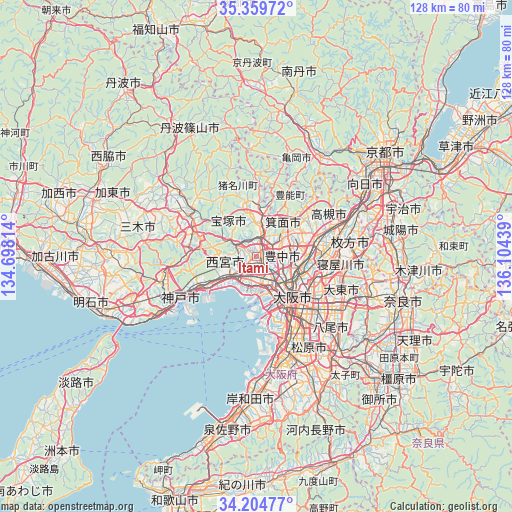
Itami GPS coordinates[2]
34° 47' 3.372" North, 135° 24' 4.536" East
| Map corner | latitude | longitude |
|---|---|---|
| Upper-left | 35.35972°, | 134.69814° |
| Center: | 34.78427°, | 135.40126° |
| Lower-right: | 34.20477°, | 136.10439° |
| Map W x H: | 128.4×128.4 km | = 79.8×79.8mi |
| max Lat: | 45.40944° ⇑65.2% North |
| Itami: | 34.78427° |
| min Lat: | ⇓34.8% South 24.34478° |
| min Long | Itami | max Long |
| 123° | 135.40126° | 145.575° |
| W 32.2%⇐ | ⇒67.8% E |
Elevation
Elevation of Itami is 22 m = 72 ft, and this is 62.6 m = 205 ft below average elevation for this country.
| Max E: |
1086 m = 3563 ft | 56.6% |
| Avg. | 84.6 m = 278 ft | |
| Itami | 22 m = 72 ft | |
Min E: |
-2 m = -7 ft | 43.4% |
See also: Itami elevation on elevation.city.
Geographical zone
Itami is located in North temperate zone (between Tropic of Cancer and the Arctic Circle). Distance of this Northern Tropic circle is 1261.7 km =784 mi to South.| Distance of | km | miles | from Itami |
|---|---|---|---|
| North Pole | 6139.4 | 3814.8 | to North |
| Arctic Circle | 3533.5 | 2195.6 | to North |
| Tropic Cancer | 1261.7 | 784 | to South |
| Equator | 3867.6 | 2403.2 | to South |


Nearby cities:
15 places around Itami: (largest is in red/bold)
• Amagasaki
7.6 km =4.7 mi,  169°
169°
• Ashiya
11 km =6.8 mi,  235°
235°
• Ibaraki
15.7 km =9.8 mi,  76°
76°
• Ikeda
4.9 km =3 mi,  31°
31°
• Kadoma
16.6 km =10.3 mi,  107°
107°
• Kawanishi
3.9 km =2.4 mi,  21°
21°
• Kawanishi
10.8 km =6.7 mi,  358°
358°
• Mino
7.9 km =4.9 mi,  53°
53°
• Moriguchi
16.1 km =10 mi, 110°
• Nishinomiya-hama
9.9 km =6.2 mi,  219°
219°
• Osaka
13.7 km =8.5 mi,  137°
137°
• Settsu
17.7 km =11 mi,  92°
92°
• Suita
10.8 km =6.7 mi,  103°
103°
• Takarazuka
4.4 km =2.7 mi,  292°
292°
• Toyonaka
6.2 km =3.9 mi, 91°
Sources, notices
• [Note1] Compared only with cities in Japan existing in our database
• [Src1] Map data: © OpenStreetMap contributors (CC-BY-SA)
• [Src2] Other city data from geonames.org with taken over terms of usage.
• [Src3] Geographical zone / Annual Mean Temperature by Robert A. Rohde @ Wikipedia
