Ikeda geodata
Ikeda (Ōsaka) is a seat of a second-order administrative division; located in Japan in Asia/Tokyo (GMT+9) time zone. With population of 99,476 people, there are 205 cities with bigger population in this country. Compared to other cities in Japan, 63.4% of cities are located further ↑North; 67.4% of cities are located further →East and 52.3% of cities have higher elevation than Ikeda. Note1


Ikeda GPS coordinates[2]
34° 49' 19.488" North, 135° 25' 47.28" East
| Map corner | latitude | longitude |
|---|---|---|
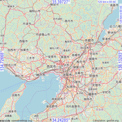
| Upper-left | 35.39727°, | 134.72668° |
| Center: | 34.82208°, | 135.4298° |
| Lower-right: | 34.24285°, | 136.13293° |
| Map W x H: | 128.4×128.4 km | = 79.8×79.8mi |
| max Lat: | 45.40944° ⇑63.4% North |
| Ikeda: | 34.82208° |
| min Lat: | ⇓36.6% South 24.34478° |
| min Long | Ikeda | max Long |
| 123° | 135.4298° | 145.575° |
| W 32.6%⇐ | ⇒67.4% E |
Elevation
Elevation of Ikeda is 26 m = 85 ft, and this is 58.6 m = 192 ft below average elevation for this country.
| Max E: |
1086 m = 3563 ft | 52.3% |
| Avg. | 84.6 m = 278 ft | |
| Ikeda | 26 m = 85 ft | |
Min E: |
-2 m = -7 ft | 47.7% |
See also: Ikeda elevation on elevation.city.
Geographical zone
Ikeda is located in North temperate zone (between Tropic of Cancer and the Arctic Circle). Distance of this Northern Tropic circle is 1265.9 km =786.6 mi to South.| Distance of | km | miles | from Ikeda |
|---|---|---|---|
| North Pole | 6135.2 | 3812.2 | to North |
| Arctic Circle | 3529.3 | 2193 | to North |
| Tropic Cancer | 1265.9 | 786.6 | to South |
| Equator | 3871.9 | 2405.9 | to South |


Nearby cities:
15 places around Ikeda: (largest is in red/bold)
• Amagasaki
11.8 km =7.3 mi,  185°
185°
• Ashiya
15.6 km =9.7 mi,  228°
228°
• Ibaraki
12.7 km =7.9 mi,  92°
92°
• Itami
4.9 km =3 mi,  211°
211°
• Kadoma
16.2 km =10.1 mi,  125°
125°
• Kawanishi
1.3 km =0.8 mi,  243°
243°
• Kawanishi
7.2 km =4.5 mi,  336°
336°
• Mino
3.8 km =2.4 mi,  81°
81°
• Moriguchi
15.9 km =9.9 mi, 128°
• Nishinomiya-hama
14.8 km =9.2 mi,  217°
217°
• Osaka
15.7 km =9.8 mi,  155°
155°
• Settsu
15.9 km =9.9 mi,  107°
107°
• Suita
10.3 km =6.4 mi, 130°
• Takarazuka
7.1 km =4.4 mi,  249°
249°
• Toyonaka
5.7 km =3.5 mi,  140°
140°
Sources, notices
• [Note1] Compared only with cities in Japan existing in our database
• [Src1] Map data: © OpenStreetMap contributors (CC-BY-SA)
• [Src2] Other city data from geonames.org with taken over terms of usage.
• [Src3] Geographical zone / Annual Mean Temperature by Robert A. Rohde @ Wikipedia
