Mino geodata
Mino (Ōsaka) is a seat of a second-order administrative division; located in Japan in Asia/Tokyo (GMT+9) time zone. With population of 129,127 people, there are 164 cities with bigger population in this country. Compared to other cities in Japan, 63.2% of cities are located further ↑North; 67% of cities are located further →East and 70.7% of cities have lower elevation than Mino. Note1


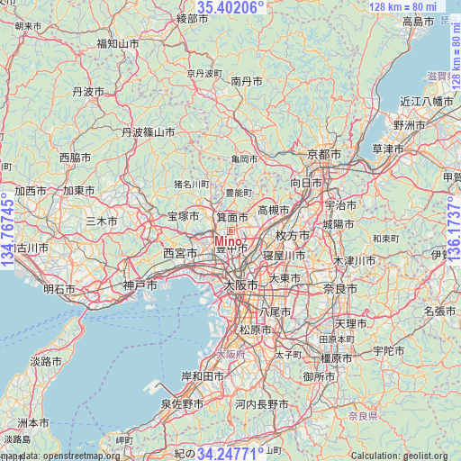
Mino GPS coordinates[2]
34° 49' 36.876" North, 135° 28' 14.052" East
| Map corner | latitude | longitude |
|---|---|---|
| Upper-left | 35.40206°, | 134.76745° |
| Center: | 34.82691°, | 135.47057° |
| Lower-right: | 34.24771°, | 136.1737° |
| Map W x H: | 128.4×128.4 km | = 79.8×79.8mi |
| max Lat: | 45.40944° ⇑63.2% North |
| Mino: | 34.82691° |
| min Lat: | ⇓36.8% South 24.34478° |
| min Long | Mino | max Long |
| 123° | 135.47057° | 145.575° |
| W 33%⇐ | ⇒67% E |
Elevation
Elevation of Mino is 76 m = 249 ft, and this is 8.6 m = 28 ft below average elevation for this country.
| Max E: |
1086 m = 3563 ft | 29.3% |
| Avg. | 84.6 m = 278 ft | |
| Mino | 76 m = 249 ft | |
Min E: |
-2 m = -7 ft | 70.7% |
See also: Mino elevation on elevation.city.
Geographical zone
Mino is located in North temperate zone (between Tropic of Cancer and the Arctic Circle). Distance of this Northern Tropic circle is 1266.5 km =787 mi to South.| Distance of | km | miles | from Mino |
|---|---|---|---|
| North Pole | 6134.7 | 3811.9 | to North |
| Arctic Circle | 3528.8 | 2192.7 | to North |
| Tropic Cancer | 1266.5 | 787 | to South |
| Equator | 3872.4 | 2406.2 | to South |


Nearby cities:
15 places around Mino: (largest is in red/bold)
• Amagasaki
13.2 km =8.2 mi,  201°
201°
• Ibaraki
9 km =5.6 mi,  97°
97°
• Ikeda
3.8 km =2.4 mi,  261°
261°
• Itami
7.9 km =4.9 mi,  233°
233°
• Kadoma
13.7 km =8.5 mi,  136°
136°
• Kawanishi
5 km =3.1 mi, 256°
• Kawanishi
8.9 km =5.5 mi,  312°
312°
• Moriguchi
13.6 km =8.5 mi, 139°
• Neyagawa
15.8 km =9.8 mi,  115°
115°
• Osaka
15.1 km =9.4 mi,  168°
168°
• Settsu
12.6 km =7.8 mi, 115°
• Suita
8.4 km =5.2 mi,  150°
150°
• Takarazuka
10.8 km =6.7 mi,  253°
253°
• Takatsuki
13.6 km =8.5 mi,  79°
79°
• Toyonaka
4.9 km =3 mi,  181°
181°
Sources, notices
• [Note1] Compared only with cities in Japan existing in our database
• [Src1] Map data: © OpenStreetMap contributors (CC-BY-SA)
• [Src2] Other city data from geonames.org with taken over terms of usage.
• [Src3] Geographical zone / Annual Mean Temperature by Robert A. Rohde @ Wikipedia
