Ushiku geodata
Ushiku (Ibaraki) is a seat of a second-order administrative division; located in Japan in Asia/Tokyo (GMT+9) time zone. With population of 80,020 people, there are 254 cities with bigger population in this country. Compared to other cities in Japan, 66.6% of cities are located further ↓South; 81.3% of cities are located further ←West and 52.3% of cities have higher elevation than Ushiku. Note1


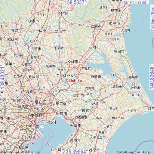
Ushiku GPS coordinates[2]
35° 58' 0.012" North, 140° 7' 59.988" East
| Map corner | latitude | longitude |
|---|---|---|
| Upper-left | 36.5337°, | 139.43021° |
| Center: | 35.96667°, | 140.13333° |
| Lower-right: | 35.39554°, | 140.83646° |
| Map W x H: | 126.6×126.6 km | = 78.7×78.7mi |
| max Lat: | 45.40944° ⇑33.4% North |
| Ushiku: | 35.96667° |
| min Lat: | ⇓66.6% South 24.34478° |
| min Long | Ushiku | max Long |
| 123° | 140.13333° | 145.575° |
| W 81.3%⇐ | ⇒18.7% E |
Elevation
Elevation of Ushiku is 26 m = 85 ft, and this is 58.6 m = 192 ft below average elevation for this country.
| Max E: |
1086 m = 3563 ft | 52.3% |
| Avg. | 84.6 m = 278 ft | |
| Ushiku | 26 m = 85 ft | |
Min E: |
-2 m = -7 ft | 47.7% |
See also: Ushiku elevation on elevation.city.
Geographical zone
Ushiku is located in North temperate zone (between Tropic of Cancer and the Arctic Circle). Distance of this Northern Tropic circle is 1393.2 km =865.7 mi to South.| Distance of | km | miles | from Ushiku |
|---|---|---|---|
| North Pole | 6007.9 | 3733.1 | to North |
| Arctic Circle | 3402.1 | 2114 | to North |
| Tropic Cancer | 1393.2 | 865.7 | to South |
| Equator | 3999.1 | 2484.9 | to South |


Nearby cities:
15 places around Ushiku: (largest is in red/bold)
• Abiko
15.3 km =9.5 mi,  223°
223°
• Ami
9.5 km =5.9 mi,  38°
38°
• Edosaki
16.6 km =10.3 mi,  96°
96°
• Fujishiro
5.8 km =3.6 mi,  195°
195°
• Inashiki
17.2 km =10.7 mi,  93°
93°
• Inzai
14.9 km =9.3 mi,  169°
169°
• Jōsō
17.3 km =10.7 mi,  296°
296°
• Kashiwa
18.2 km =11.3 mi,  230°
230°
• Mitsukaidō
14.6 km =9.1 mi,  292°
292°
• Moriya
12.6 km =7.8 mi,  252°
252°
• Naka
9.7 km =6 mi,  17°
17°
• Ryūgasaki
8.7 km =5.4 mi,  148°
148°
• Toride
8.7 km =5.4 mi,  211°
211°
• Tsuchiura
15.4 km =9.6 mi,  26°
26°
• Tsukubamirai
11.3 km =7 mi,  279°
279°
Sources, notices
• [Note1] Compared only with cities in Japan existing in our database
• [Src1] Map data: © OpenStreetMap contributors (CC-BY-SA)
• [Src2] Other city data from geonames.org with taken over terms of usage.
• [Src3] Geographical zone / Annual Mean Temperature by Robert A. Rohde @ Wikipedia
