Tsukuba geodata
Tsukuba (Ibaraki) is a seat of a second-order administrative division; located in Japan in Asia/Tokyo (GMT+9) time zone. With population of 175,589 people, there are 116 cities with bigger population in this country. Compared to other cities in Japan, 71.5% of cities are located further ↓South; 80.1% of cities are located further ←West and 53.8% of cities have lower elevation than Tsukuba. Note1


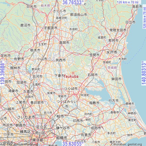
Tsukuba GPS coordinates[2]
36° 12' 0" North, 140° 6' 0" East
| Map corner | latitude | longitude |
|---|---|---|
| Upper-left | 36.76533°, | 139.39688° |
| Center: | 36.2°, | 140.1° |
| Lower-right: | 35.63055°, | 140.80313° |
| Map W x H: | 126.2×126.2 km | = 78.4×78.4mi |
| max Lat: | 45.40944° ⇑28.5% North |
| Tsukuba: | 36.2° |
| min Lat: | ⇓71.5% South 24.34478° |
| min Long | Tsukuba | max Long |
| 123° | 140.1° | 145.575° |
| W 80.1%⇐ | ⇒19.9% E |
Elevation
Elevation of Tsukuba is 33 m = 108 ft, and this is 51.6 m = 169 ft below average elevation for this country.
| Max E: |
1086 m = 3563 ft | 46.2% |
| Avg. | 84.6 m = 278 ft | |
| Tsukuba | 33 m = 108 ft | |
Min E: |
-2 m = -7 ft | 53.8% |
See also: Tsukuba elevation on elevation.city.
Geographical zone
Tsukuba is located in North temperate zone (between Tropic of Cancer and the Arctic Circle). Distance of this Northern Tropic circle is 1419.1 km =881.8 mi to South.| Distance of | km | miles | from Tsukuba |
|---|---|---|---|
| North Pole | 5982 | 3717 | to North |
| Arctic Circle | 3376.1 | 2097.8 | to North |
| Tropic Cancer | 1419.1 | 881.8 | to South |
| Equator | 4025.1 | 2501.1 | to South |


Nearby cities:
15 places around Tsukuba: (largest is in red/bold)
• Ami
20.6 km =12.8 mi,  154°
154°
• Chikusei
16.7 km =10.4 mi,  320°
320°
• Ishige
15.1 km =9.4 mi,  232°
232°
• Ishioka
15.1 km =9.4 mi,  97°
97°
• Iwase
16.7 km =10.4 mi,  0°
0°
• Jōsō
22.1 km =13.7 mi,  214°
214°
• Kasumigaura
14.1 km =8.8 mi,  111°
111°
• Makabe
7.4 km =4.6 mi, 0°
• Mitsukaidō
22.9 km =14.2 mi, 207°
• Naka
17.7 km =11 mi,  160°
160°
• Sakuragawa
5.8 km =3.6 mi,  14°
14°
• Shimo-tsuma
12.1 km =7.5 mi,  261°
261°
• Shimodate
15.3 km =9.5 mi, 316°
• Tsuchiura
15.7 km =9.8 mi,  140°
140°
• Yūki
22.4 km =13.9 mi,  299°
299°
Sources, notices
• [Note1] Compared only with cities in Japan existing in our database
• [Src1] Map data: © OpenStreetMap contributors (CC-BY-SA)
• [Src2] Other city data from geonames.org with taken over terms of usage.
• [Src3] Geographical zone / Annual Mean Temperature by Robert A. Rohde @ Wikipedia
