Sakuragawa geodata
Sakuragawa (Ibaraki) is a seat of a second-order administrative division; located in Japan in Asia/Tokyo (GMT+9) time zone. In our database, there are 767 cities with bigger population. Compared to other cities in Japan, 72.7% of cities are located further ↓South; 80.6% of cities are located further ←West and 89.3% of cities have lower elevation than Sakuragawa. Note1


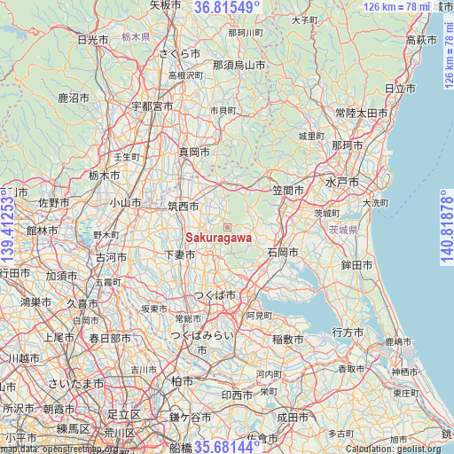
Sakuragawa GPS coordinates[2]
36° 15' 1.872" North, 140° 6' 56.34" East
| Map corner | latitude | longitude |
|---|---|---|
| Upper-left | 36.81549°, | 139.41253° |
| Center: | 36.25052°, | 140.11565° |
| Lower-right: | 35.68144°, | 140.81878° |
| Map W x H: | 126.1×126.1 km | = 78.4×78.4mi |
| max Lat: | 45.40944° ⇑27.3% North |
| Sakuragawa: | 36.25052° |
| min Lat: | ⇓72.7% South 24.34478° |
| min Long | Sakuragawa | max Long |
| 123° | 140.11565° | 145.575° |
| W 80.6%⇐ | ⇒19.4% E |
Elevation
Elevation of Sakuragawa is 211 m = 692 ft, and this is 126.4 m = 415 ft above average elevation for this country.
| Max E: |
1086 m = 3563 ft | 10.7% |
| Sakuragawa | 211 m 692 ft | |
| Avg. | 84.6 m = 278 ft | |
Min E: |
-2 m = -7 ft | 89.3% |
See also: Japan elevation on elevation.city.
Geographical zone
Sakuragawa is located in North temperate zone (between Tropic of Cancer and the Arctic Circle). Distance of this Northern Tropic circle is 1424.8 km =885.3 mi to South.| Distance of | km | miles | from Sakuragawa |
|---|---|---|---|
| North Pole | 5976.4 | 3713.6 | to North |
| Arctic Circle | 3370.5 | 2094.3 | to North |
| Tropic Cancer | 1424.8 | 885.3 | to South |
| Equator | 4030.7 | 2504.6 | to South |


Nearby cities:
15 places around Sakuragawa: (largest is in red/bold)
• Chikusei
14 km =8.7 mi,  301°
301°
• Ishige
20 km =12.4 mi,  221°
221°
• Ishioka
15.5 km =9.6 mi,  118°
118°
• Iwase
11.1 km =6.9 mi,  352°
352°
• Kasama
20 km =12.4 mi,  42°
42°
• Kasumigaura
16 km =9.9 mi,  132°
132°
• Makabe
2.3 km =1.4 mi,  321°
321°
• Mooka
22.2 km =13.8 mi,  336°
336°
• Naka
22.8 km =14.2 mi,  168°
168°
• Shimo-tsuma
15.3 km =9.5 mi,  240°
240°
• Shimodate
13.1 km =8.1 mi,  294°
294°
• Tomobe
19.9 km =12.4 mi,  56°
56°
• Tsuchiura
19.7 km =12.2 mi,  154°
154°
• Tsukuba
5.8 km =3.6 mi,  194°
194°
• Yūki
21.5 km =13.4 mi,  284°
284°
Sources, notices
• [Note1] Compared only with cities in Japan existing in our database
• [Src1] Map data: © OpenStreetMap contributors (CC-BY-SA)
• [Src2] Other city data from geonames.org with taken over terms of usage.
• [Src3] Geographical zone / Annual Mean Temperature by Robert A. Rohde @ Wikipedia
