Narita geodata
Narita (Chiba) is a seat of a second-order administrative division; located in Japan in Asia/Tokyo (GMT+9) time zone. With population of 100,641 people, there are 199 cities with bigger population in this country. Compared to other cities in Japan, 61.5% of cities are located further ↓South; 83.4% of cities are located further ←West and 51.1% of cities have higher elevation than Narita. Note1


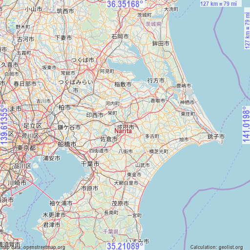
Narita GPS coordinates[2]
35° 46' 59.988" North, 140° 19' 0.012" East
| Map corner | latitude | longitude |
|---|---|---|
| Upper-left | 36.35168°, | 139.61355° |
| Center: | 35.78333°, | 140.31667° |
| Lower-right: | 35.21089°, | 141.0198° |
| Map W x H: | 126.8×126.8 km | = 78.8×78.8mi |
| max Lat: | 45.40944° ⇑38.5% North |
| Narita: | 35.78333° |
| min Lat: | ⇓61.5% South 24.34478° |
| min Long | Narita | max Long |
| 123° | 140.31667° | 145.575° |
| W 83.4%⇐ | ⇒16.6% E |
Elevation
Elevation of Narita is 27 m = 89 ft, and this is 57.6 m = 189 ft below average elevation for this country.
| Max E: |
1086 m = 3563 ft | 51.1% |
| Avg. | 84.6 m = 278 ft | |
| Narita | 27 m = 89 ft | |
Min E: |
-2 m = -7 ft | 48.9% |
See also: Narita elevation on elevation.city.
Geographical zone
Narita is located in North temperate zone (between Tropic of Cancer and the Arctic Circle). Distance of this Northern Tropic circle is 1372.8 km =853 mi to South.| Distance of | km | miles | from Narita |
|---|---|---|---|
| North Pole | 6028.3 | 3745.8 | to North |
| Arctic Circle | 3422.4 | 2126.6 | to North |
| Tropic Cancer | 1372.8 | 853 | to South |
| Equator | 3978.7 | 2472.2 | to South |


Nearby cities:
15 places around Narita: (largest is in red/bold)
• Edosaki
18.5 km =11.5 mi,  0°
0°
• Inashiki
19.2 km =11.9 mi, 1°
• Inzai
14.9 km =9.3 mi,  292°
292°
• Katori-shi
20.8 km =12.9 mi,  52°
52°
• Narutō
22.3 km =13.9 mi,  156°
156°
• Ryūgasaki
17.7 km =11 mi,  317°
317°
• Sakura
10.6 km =6.6 mi,  225°
225°
• Sanmu
19.6 km =12.2 mi,  152°
152°
• Sawara
19.9 km =12.4 mi,  56°
56°
• Shisui
8.7 km =5.4 mi,  211°
211°
• Sōsa
22.6 km =14 mi,  109°
109°
• Tomisato
9 km =5.6 mi,  118°
118°
• Yachimata
14.8 km =9.2 mi,  180°
180°
• Yachiyo
18.1 km =11.2 mi,  252°
252°
• Yotsukaidō
20.1 km =12.5 mi,  222°
222°
Sources, notices
• [Note1] Compared only with cities in Japan existing in our database
• [Src1] Map data: © OpenStreetMap contributors (CC-BY-SA)
• [Src2] Other city data from geonames.org with taken over terms of usage.
• [Src3] Geographical zone / Annual Mean Temperature by Robert A. Rohde @ Wikipedia
