Katori-shi geodata
Katori-shi (Chiba) is a seat of a second-order administrative division; located in Japan in Asia/Tokyo (GMT+9) time zone. With population of 83,181 people, there are 239 cities with bigger population in this country. Compared to other cities in Japan, 64.9% of cities are located further ↓South; 87% of cities are located further ←West and 86% of cities have higher elevation than Katori-shi. Note1


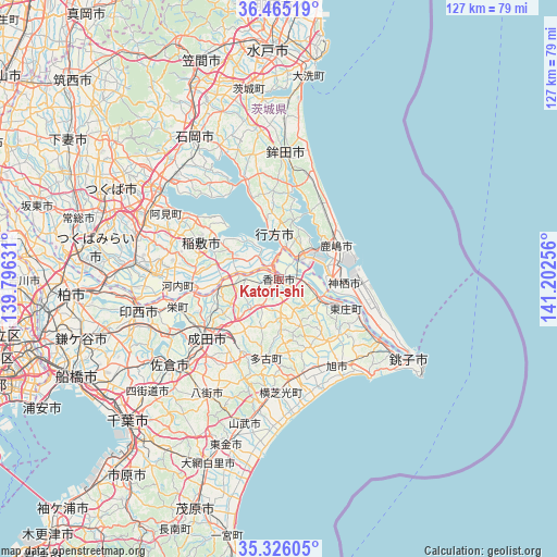
Katori-shi GPS coordinates[2]
35° 53' 51.612" North, 140° 29' 57.948" East
| Map corner | latitude | longitude |
|---|---|---|
| Upper-left | 36.46519°, | 139.79631° |
| Center: | 35.89767°, | 140.49943° |
| Lower-right: | 35.32605°, | 141.20256° |
| Map W x H: | 126.7×126.7 km | = 78.7×78.7mi |
| max Lat: | 45.40944° ⇑35.1% North |
| Katori-shi: | 35.89767° |
| min Lat: | ⇓64.9% South 24.34478° |
| min Long | Katori-shi | max Long |
| 123° | 140.49943° | 145.575° |
| W 87%⇐ | ⇒13% E |
Elevation
Elevation of Katori-shi is 6 m = 20 ft, and this is 78.6 m = 258 ft below average elevation for this country.
| Max E: |
1086 m = 3563 ft | 86% |
| Avg. | 84.6 m = 278 ft | |
| Katori-shi | 6 m = 20 ft | |
Min E: |
-2 m = -7 ft | 14% |
See also: Katori-shi elevation on elevation.city.
Geographical zone
Katori-shi is located in North temperate zone (between Tropic of Cancer and the Arctic Circle). Distance of this Northern Tropic circle is 1385.5 km =860.9 mi to South.| Distance of | km | miles | from Katori-shi |
|---|---|---|---|
| North Pole | 6015.6 | 3737.9 | to North |
| Arctic Circle | 3409.7 | 2118.7 | to North |
| Tropic Cancer | 1385.5 | 860.9 | to South |
| Equator | 3991.4 | 2480.1 | to South |


Nearby cities:
15 places around Katori-shi: (largest is in red/bold)
• Asahi
24.3 km =15.1 mi,  145°
145°
• Edosaki
17.5 km =10.9 mi,  289°
289°
• Hokota
28.1 km =17.5 mi,  3°
3°
• Inashiki
17.1 km =10.6 mi, 292°
• Itako
6 km =3.7 mi,  48°
48°
• Kamisu
15.1 km =9.4 mi,  90°
90°
• Kashima-shi
15.1 km =9.4 mi,  60°
60°
• Namegata
12.2 km =7.6 mi,  358°
358°
• Narita
20.8 km =12.9 mi,  232°
232°
• Omigawa
11.8 km =7.3 mi,  116°
116°
• Ryūgasaki
28.5 km =17.7 mi,  270°
270°
• Sawara
1.6 km =1 mi,  178°
178°
• Sōsa
20.8 km =12.9 mi,  166°
166°
• Tomisato
19.1 km =11.9 mi,  206°
206°
• Yōkaichiba
22.4 km =13.9 mi, 168°
Sources, notices
• [Note1] Compared only with cities in Japan existing in our database
• [Src1] Map data: © OpenStreetMap contributors (CC-BY-SA)
• [Src2] Other city data from geonames.org with taken over terms of usage.
• [Src3] Geographical zone / Annual Mean Temperature by Robert A. Rohde @ Wikipedia
