Sakura geodata
Sakura (Chiba) is a seat of a second-order administrative division; located in Japan in Asia/Tokyo (GMT+9) time zone. With population of 182,549 people, there are 113 cities with bigger population in this country. Compared to other cities in Japan, 58.9% of cities are located further ↓South; 82.3% of cities are located further ←West and 65.3% of cities have higher elevation than Sakura. Note1


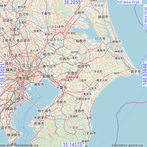
Sakura GPS coordinates[2]
35° 43' 0.012" North, 140° 13' 59.988" East
| Map corner | latitude | longitude |
|---|---|---|
| Upper-left | 36.2855°, | 139.53021° |
| Center: | 35.71667°, | 140.23333° |
| Lower-right: | 35.14375°, | 140.93646° |
| Map W x H: | 127×127 km | = 78.9×78.9mi |
| max Lat: | 45.40944° ⇑41.1% North |
| Sakura: | 35.71667° |
| min Lat: | ⇓58.9% South 24.34478° |
| min Long | Sakura | max Long |
| 123° | 140.23333° | 145.575° |
| W 82.3%⇐ | ⇒17.7% E |
Elevation
Elevation of Sakura is 15 m = 49 ft, and this is 69.6 m = 228 ft below average elevation for this country.
| Max E: |
1086 m = 3563 ft | 65.3% |
| Avg. | 84.6 m = 278 ft | |
| Sakura | 15 m = 49 ft | |
Min E: |
-2 m = -7 ft | 34.7% |
See also: Sakura elevation on elevation.city.
Geographical zone
Sakura is located in North temperate zone (between Tropic of Cancer and the Arctic Circle). Distance of this Northern Tropic circle is 1365.4 km =848.4 mi to South.| Distance of | km | miles | from Sakura |
|---|---|---|---|
| North Pole | 6035.7 | 3750.4 | to North |
| Arctic Circle | 3429.9 | 2131.2 | to North |
| Tropic Cancer | 1365.4 | 848.4 | to South |
| Equator | 3971.3 | 2467.7 | to South |


Nearby cities:
15 places around Sakura: (largest is in red/bold)
• Chiba
16.7 km =10.4 mi,  219°
219°
• Funabashi
20 km =12.4 mi,  271°
271°
• Inzai
14.6 km =9.1 mi,  334°
334°
• Kamagaya
21.7 km =13.5 mi,  285°
285°
• Narashino
17.7 km =11 mi,  257°
257°
• Narita
10.6 km =6.6 mi,  45°
45°
• Narutō
21 km =13 mi,  128°
128°
• Ryūgasaki
20.9 km =13 mi,  347°
347°
• Sanmu
19.4 km =12.1 mi,  120°
120°
• Shiroi
17.7 km =11 mi,  301°
301°
• Shisui
3 km =1.9 mi,  90°
90°
• Tomisato
15.7 km =9.8 mi,  78°
78°
• Yachimata
10.6 km =6.6 mi, 134°
• Yachiyo
10 km =6.2 mi,  281°
281°
• Yotsukaidō
9.5 km =5.9 mi, 219°
Sources, notices
• [Note1] Compared only with cities in Japan existing in our database
• [Src1] Map data: © OpenStreetMap contributors (CC-BY-SA)
• [Src2] Other city data from geonames.org with taken over terms of usage.
• [Src3] Geographical zone / Annual Mean Temperature by Robert A. Rohde @ Wikipedia
