Iwamizawa geodata
Iwamizawa (Hokkaido) is a seat of a second-order administrative division; located in Japan in Asia/Tokyo (GMT+9) time zone. With population of 85,107 people, there are 235 cities with bigger population in this country. Compared to other cities in Japan, 97.4% of cities are located further ↓South; 96.9% of cities are located further ←West and 62.8% of cities have higher elevation than Iwamizawa. Note1


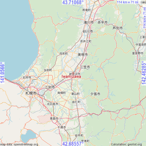
Iwamizawa GPS coordinates[2]
43° 12' 1.008" North, 141° 45' 34.992" East
| Map corner | latitude | longitude |
|---|---|---|
| Upper-left | 43.71068°, | 141.0566° |
| Center: | 43.20028°, | 141.75972° |
| Lower-right: | 42.68557°, | 142.46285° |
| Map W x H: | 114×114 km | = 70.8×70.8mi |
| max Lat: | 45.40944° ⇑2.6% North |
| Iwamizawa: | 43.20028° |
| min Lat: | ⇓97.4% South 24.34478° |
| min Long | Iwamizawa | max Long |
| 123° | 141.75972° | 145.575° |
| W 96.9%⇐ | ⇒3.1% E |
Elevation
Elevation of Iwamizawa is 17 m = 56 ft, and this is 67.6 m = 222 ft below average elevation for this country.
| Max E: |
1086 m = 3563 ft | 62.8% |
| Avg. | 84.6 m = 278 ft | |
| Iwamizawa | 17 m = 56 ft | |
Min E: |
-2 m = -7 ft | 37.2% |
See also: Iwamizawa elevation on elevation.city.
Geographical zone
Iwamizawa is located in North temperate zone (between Tropic of Cancer and the Arctic Circle). Distance of this Northern Tropic circle is 2197.5 km =1365.5 mi to South.| Distance of | km | miles | from Iwamizawa |
|---|---|---|---|
| North Pole | 5203.6 | 3233.4 | to North |
| Arctic Circle | 2597.8 | 1614.2 | to North |
| Tropic Cancer | 2197.5 | 1365.5 | to South |
| Equator | 4803.4 | 2984.7 | to South |


Nearby cities:
15 places around Iwamizawa: (largest is in red/bold)
• Akabira
45.7 km =28.4 mi,  31°
31°
• Ashibetsu
48.7 km =30.3 mi,  45°
45°
• Bibai
16 km =9.9 mi, 30°
• Chitose
43.2 km =26.8 mi,  191°
191°
• Ebetsu
19.8 km =12.3 mi,  238°
238°
• Eniwa
37.2 km =23.1 mi,  203°
203°
• Ishikari
33.2 km =20.6 mi,  277°
277°
• Kitahiroshima
29.4 km =18.3 mi,  212°
212°
• Mikasa
12.1 km =7.5 mi,  59°
59°
• Sapporo
36.4 km =22.6 mi,  245°
245°
• Sunagawa
33.9 km =21.1 mi,  20°
20°
• Takikawa
40.9 km =25.4 mi, 16°
• Tōbetsu
19.8 km =12.3 mi, 275°
• Utashinai
42.3 km =26.3 mi, 33°
• Yūbari
24.2 km =15 mi,  138°
138°
Sources, notices
• [Note1] Compared only with cities in Japan existing in our database
• [Src1] Map data: © OpenStreetMap contributors (CC-BY-SA)
• [Src2] Other city data from geonames.org with taken over terms of usage.
• [Src3] Geographical zone / Annual Mean Temperature by Robert A. Rohde @ Wikipedia
