Akabira geodata
Akabira (Hokkaido) is a seat of a second-order administrative division; located in Japan in Asia/Tokyo (GMT+9) time zone. With population of 14,214 people, there are 739 cities with bigger population in this country. Compared to other cities in Japan, 98.5% of cities are located further ↓South; 98.2% of cities are located further ←West and 65% of cities have lower elevation than Akabira. Note1


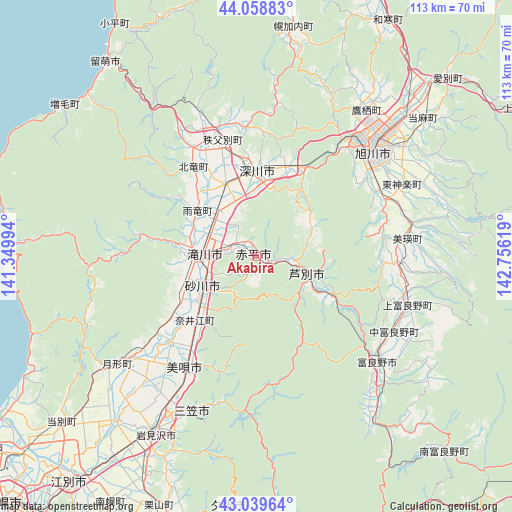
Akabira GPS coordinates[2]
43° 33' 5.004" North, 142° 3' 11.016" East
| Map corner | latitude | longitude |
|---|---|---|
| Upper-left | 44.05883°, | 141.34994° |
| Center: | 43.55139°, | 142.05306° |
| Lower-right: | 43.03964°, | 142.75619° |
| Map W x H: | 113.3×113.3 km | = 70.4×70.4mi |
| max Lat: | 45.40944° ⇑1.5% North |
| Akabira: | 43.55139° |
| min Lat: | ⇓98.5% South 24.34478° |
| min Long | Akabira | max Long |
| 123° | 142.05306° | 145.575° |
| W 98.2%⇐ | ⇒1.8% E |
Elevation
Elevation of Akabira is 57 m = 187 ft, and this is 27.6 m = 91 ft below average elevation for this country.
| Max E: |
1086 m = 3563 ft | 35% |
| Avg. | 84.6 m = 278 ft | |
| Akabira | 57 m = 187 ft | |
Min E: |
-2 m = -7 ft | 65% |
See also: Japan elevation on elevation.city.
Geographical zone
Akabira is located in North temperate zone (between Tropic of Cancer and the Arctic Circle). Distance of this Northern Tropic circle is 2236.5 km =1389.7 mi to South.| Distance of | km | miles | from Akabira |
|---|---|---|---|
| North Pole | 5164.6 | 3209.1 | to North |
| Arctic Circle | 2558.7 | 1589.9 | to North |
| Tropic Cancer | 2236.5 | 1389.7 | to South |
| Equator | 4842.5 | 3009 | to South |


Nearby cities:
15 places around Akabira: (largest is in red/bold)
• Asahikawa
35 km =21.7 mi,  45°
45°
• Ashibetsu
11.6 km =7.2 mi,  113°
113°
• Bibai
29.7 km =18.5 mi,  211°
211°
• Ebetsu
63.9 km =39.7 mi,  219°
219°
• Fukagawa
17.5 km =10.9 mi,  356°
356°
• Furano
34.8 km =21.6 mi,  130°
130°
• Iwamizawa
45.7 km =28.4 mi, 211°
• Mikasa
35.5 km =22.1 mi,  202°
202°
• Rumoi
53.9 km =33.5 mi,  322°
322°
• Shimo-furano
34.8 km =21.6 mi, 130°
• Sunagawa
13.9 km =8.6 mi,  238°
238°
• Takikawa
11.8 km =7.3 mi,  270°
270°
• Tōbetsu
57.1 km =35.5 mi,  229°
229°
• Utashinai
3.9 km =2.4 mi,  183°
183°
• Yūbari
57.6 km =35.8 mi,  187°
187°
Sources, notices
• [Note1] Compared only with cities in Japan existing in our database
• [Src1] Map data: © OpenStreetMap contributors (CC-BY-SA)
• [Src2] Other city data from geonames.org with taken over terms of usage.
• [Src3] Geographical zone / Annual Mean Temperature by Robert A. Rohde @ Wikipedia
