Musashimurayama geodata
Musashimurayama (Tokyo) is a seat of a second-order administrative division; located in Japan in Asia/Tokyo (GMT+9) time zone. In our database, there are 767 cities with bigger population. Compared to other cities in Japan, 60.6% of cities are located further ↓South; 67% of cities are located further ←West and 75.8% of cities have lower elevation than Musashimurayama. Note1


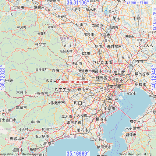
Musashimurayama GPS coordinates[2]
35° 44' 32.712" North, 139° 25' 34.86" East
| Map corner | latitude | longitude |
|---|---|---|
| Upper-left | 36.31106°, | 138.72323° |
| Center: | 35.74242°, | 139.42635° |
| Lower-right: | 35.16969°, | 140.12948° |
| Map W x H: | 126.9×126.9 km | = 78.9×78.9mi |
| max Lat: | 45.40944° ⇑39.4% North |
| Musashimurayama: | 35.74242° |
| min Lat: | ⇓60.6% South 24.34478° |
| min Long | Musashimurayama | max Long |
| 123° | 139.42635° | 145.575° |
| W 67%⇐ | ⇒33% E |
Elevation
Elevation of Musashimurayama is 99 m = 325 ft, and this is 14.4 m = 47 ft above average elevation for this country.
| Max E: |
1086 m = 3563 ft | 24.2% |
| Musashimurayama | 99 m 325 ft | |
| Avg. | 84.6 m = 278 ft | |
Min E: |
-2 m = -7 ft | 75.8% |
See also: Japan elevation on elevation.city.
Geographical zone
Musashimurayama is located in North temperate zone (between Tropic of Cancer and the Arctic Circle). Distance of this Northern Tropic circle is 1368.3 km =850.2 mi to South.| Distance of | km | miles | from Musashimurayama |
|---|---|---|---|
| North Pole | 6032.9 | 3748.7 | to North |
| Arctic Circle | 3427 | 2129.4 | to North |
| Tropic Cancer | 1368.3 | 850.2 | to South |
| Equator | 3974.2 | 2469.5 | to South |


Nearby cities:
15 places around Musashimurayama: (largest is in red/bold)
• Akishima
4.8 km =3 mi,  240°
240°
• Fuchū
9.1 km =5.7 mi,  146°
146°
• Fussa
9.3 km =5.8 mi,  266°
266°
• Hamura
9.9 km =6.2 mi,  282°
282°
• Higashikurume
7.8 km =4.8 mi,  82°
82°
• Higashimurayama
4 km =2.5 mi,  70°
70°
• Higashiyamato
0.9 km =0.6 mi,  17°
17°
• Higashiyamato
2.9 km =1.8 mi,  37°
37°
• Hino
8.1 km =5 mi,  196°
196°
• Kodaira
5.6 km =3.5 mi,  108°
108°
• Koganei
9 km =5.6 mi,  121°
121°
• Kokubunji
6.3 km =3.9 mi,  135°
135°
• Kunitachi
6.7 km =4.2 mi,  170°
170°
• Tachikawa
3.8 km =2.4 mi,  190°
190°
• Tokorozawa
7.4 km =4.6 mi,  31°
31°
Sources, notices
• [Note1] Compared only with cities in Japan existing in our database
• [Src1] Map data: © OpenStreetMap contributors (CC-BY-SA)
• [Src2] Other city data from geonames.org with taken over terms of usage.
• [Src3] Geographical zone / Annual Mean Temperature by Robert A. Rohde @ Wikipedia
