Tokorozawa geodata
Tokorozawa (Saitama) is a seat of a second-order administrative division; located in Japan in Asia/Tokyo (GMT+9) time zone. With population of 339,435 people, there are 55 cities with bigger population in this country. Compared to other cities in Japan, 61.7% of cities are located further ↓South; 68.1% of cities are located further ←West and 72.4% of cities have lower elevation than Tokorozawa. Note1


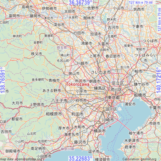
Tokorozawa GPS coordinates[2]
35° 47' 56.976" North, 139° 28' 8.508" East
| Map corner | latitude | longitude |
|---|---|---|
| Upper-left | 36.36739°, | 138.76591° |
| Center: | 35.79916°, | 139.46903° |
| Lower-right: | 35.22683°, | 140.17216° |
| Map W x H: | 126.8×126.8 km | = 78.8×78.8mi |
| max Lat: | 45.40944° ⇑38.3% North |
| Tokorozawa: | 35.79916° |
| min Lat: | ⇓61.7% South 24.34478° |
| min Long | Tokorozawa | max Long |
| 123° | 139.46903° | 145.575° |
| W 68.1%⇐ | ⇒31.9% E |
Elevation
Elevation of Tokorozawa is 82 m = 269 ft, and this is 2.6 m = 9 ft below average elevation for this country.
| Max E: |
1086 m = 3563 ft | 27.6% |
| Avg. | 84.6 m = 278 ft | |
| Tokorozawa | 82 m = 269 ft | |
Min E: |
-2 m = -7 ft | 72.4% |
See also: Tokorozawa elevation on elevation.city.
Geographical zone
Tokorozawa is located in North temperate zone (between Tropic of Cancer and the Arctic Circle). Distance of this Northern Tropic circle is 1374.6 km =854.1 mi to South.| Distance of | km | miles | from Tokorozawa |
|---|---|---|---|
| North Pole | 6026.6 | 3744.8 | to North |
| Arctic Circle | 3420.7 | 2125.5 | to North |
| Tropic Cancer | 1374.6 | 854.1 | to South |
| Equator | 3980.5 | 2473.4 | to South |


Nearby cities:
15 places around Tokorozawa: (largest is in red/bold)
• Fujimi
9.5 km =5.9 mi,  54°
54°
• Fujimino
8.1 km =5 mi,  31°
31°
• Higashikurume
6.5 km =4 mi,  143°
143°
• Higashimurayama
5 km =3.1 mi,  180°
180°
• Higashiyamato
4.5 km =2.8 mi,  207°
207°
• Higashiyamato
6.5 km =4 mi, 213°
• Iruma
9.3 km =5.8 mi,  282°
282°
• Kamifukuoka
9.1 km =5.7 mi, 26°
• Kiyose
5.9 km =3.7 mi,  111°
111°
• Kodaira
8.3 km =5.2 mi,  169°
169°
• Musashimurayama
7.4 km =4.6 mi, 211°
• Niiza
8.4 km =5.2 mi,  73°
73°
• Sayama
7.9 km =4.9 mi,  319°
319°
• Tanashichō
10 km =6.2 mi, 141°
• Ōi
7.4 km =4.6 mi,  38°
38°
Sources, notices
• [Note1] Compared only with cities in Japan existing in our database
• [Src1] Map data: © OpenStreetMap contributors (CC-BY-SA)
• [Src2] Other city data from geonames.org with taken over terms of usage.
• [Src3] Geographical zone / Annual Mean Temperature by Robert A. Rohde @ Wikipedia
