Higashiyamato geodata
Higashiyamato (Tokyo) is a seat of a second-order administrative division; located in Japan in Asia/Tokyo (GMT+9) time zone. In our database, there are 767 cities with bigger population. Compared to other cities in Japan, 61.1% of cities are located further ↓South; 67.3% of cities are located further ←West and 71.2% of cities have lower elevation than Higashiyamato. Note1


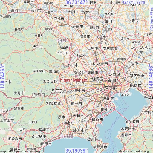
Higashiyamato GPS coordinates[2]
35° 45' 46.728" North, 139° 26' 44.7" East
| Map corner | latitude | longitude |
|---|---|---|
| Upper-left | 36.33147°, | 138.74263° |
| Center: | 35.76298°, | 139.44575° |
| Lower-right: | 35.19039°, | 140.14888° |
| Map W x H: | 126.9×126.9 km | = 78.9×78.9mi |
| max Lat: | 45.40944° ⇑38.9% North |
| Higashiyamato: | 35.76298° |
| min Lat: | ⇓61.1% South 24.34478° |
| min Long | Higashiyamato | max Long |
| 123° | 139.44575° | 145.575° |
| W 67.3%⇐ | ⇒32.7% E |
Elevation
Elevation of Higashiyamato is 78 m = 256 ft, and this is 6.6 m = 22 ft below average elevation for this country.
| Max E: |
1086 m = 3563 ft | 28.8% |
| Avg. | 84.6 m = 278 ft | |
| Higashiyamato | 78 m = 256 ft | |
Min E: |
-2 m = -7 ft | 71.2% |
See also: Japan elevation on elevation.city.
Geographical zone
Higashiyamato is located in North temperate zone (between Tropic of Cancer and the Arctic Circle). Distance of this Northern Tropic circle is 1370.6 km =851.7 mi to South.| Distance of | km | miles | from Higashiyamato |
|---|---|---|---|
| North Pole | 6030.6 | 3747.2 | to North |
| Arctic Circle | 3424.7 | 2128 | to North |
| Tropic Cancer | 1370.6 | 851.7 | to South |
| Equator | 3976.5 | 2470.9 | to South |


Nearby cities:
15 places around Higashiyamato: (largest is in red/bold)
• Akishima
7.6 km =4.7 mi,  231°
231°
• Higashikurume
6.1 km =3.8 mi,  101°
101°
• Higashimurayama
2.3 km =1.4 mi,  114°
114°
• Higashiyamato
2 km =1.2 mi, 226°
• Iruma
9.3 km =5.8 mi,  311°
311°
• Kiyose
7.8 km =4.8 mi,  76°
76°
• Kodaira
5.4 km =3.4 mi,  139°
139°
• Koganei
9.1 km =5.7 mi, 139°
• Kokubunji
7.3 km =4.5 mi,  158°
158°
• Kunitachi
8.9 km =5.5 mi,  184°
184°
• Musashimurayama
2.9 km =1.8 mi,  217°
217°
• Nishi-Tokyo-shi
9.3 km =5.8 mi,  116°
116°
• Tachikawa
6.5 km =4 mi,  202°
202°
• Tanashichō
9.1 km =5.7 mi, 114°
• Tokorozawa
4.5 km =2.8 mi,  27°
27°
Sources, notices
• [Note1] Compared only with cities in Japan existing in our database
• [Src1] Map data: © OpenStreetMap contributors (CC-BY-SA)
• [Src2] Other city data from geonames.org with taken over terms of usage.
• [Src3] Geographical zone / Annual Mean Temperature by Robert A. Rohde @ Wikipedia
