Buzen geodata
Buzen (Fukuoka) is a seat of a second-order administrative division; located in Japan in Asia/Tokyo (GMT+9) time zone. With population of 26,886 people, there are 581 cities with bigger population in this country. Compared to other cities in Japan, 83.9% of cities are located further ↑North; 86.4% of cities are located further →East and 59.1% of cities have higher elevation than Buzen. Note1


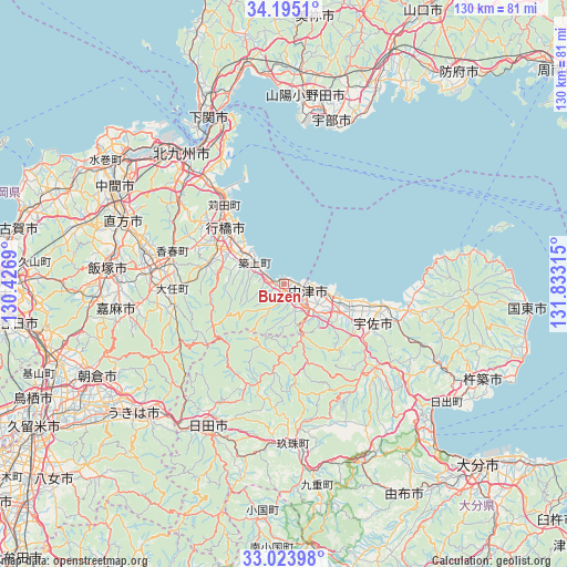
Buzen GPS coordinates[2]
33° 36' 41.508" North, 131° 7' 48.072" East
| Map corner | latitude | longitude |
|---|---|---|
| Upper-left | 34.1951°, | 130.4269° |
| Center: | 33.61153°, | 131.13002° |
| Lower-right: | 33.02398°, | 131.83315° |
| Map W x H: | 130.2×130.2 km | = 80.9×80.9mi |
| max Lat: | 45.40944° ⇑83.9% North |
| Buzen: | 33.61153° |
| min Lat: | ⇓16.1% South 24.34478° |
| min Long | Buzen | max Long |
| 123° | 131.13002° | 145.575° |
| W 13.6%⇐ | ⇒86.4% E |
Elevation
Elevation of Buzen is 20 m = 66 ft, and this is 64.6 m = 212 ft below average elevation for this country.
| Max E: |
1086 m = 3563 ft | 59.1% |
| Avg. | 84.6 m = 278 ft | |
| Buzen | 20 m = 66 ft | |
Min E: |
-2 m = -7 ft | 40.9% |
See also: Japan elevation on elevation.city.
Geographical zone
Buzen is located in North temperate zone (between Tropic of Cancer and the Arctic Circle). Distance of this Northern Tropic circle is 1131.3 km =703 mi to South.| Distance of | km | miles | from Buzen |
|---|---|---|---|
| North Pole | 6269.8 | 3895.9 | to North |
| Arctic Circle | 3663.9 | 2276.6 | to North |
| Tropic Cancer | 1131.3 | 703 | to South |
| Equator | 3737.3 | 2322.2 | to South |


Nearby cities:
15 places around Buzen: (largest is in red/bold)
• Bungo-Takada-shi
29.8 km =18.5 mi,  101°
101°
• Hita
36.7 km =22.8 mi,  208°
208°
• Kama
36.9 km =22.9 mi,  256°
256°
• Kanda
23.4 km =14.5 mi,  324°
324°
• Kawasaki
29.2 km =18.1 mi,  267°
267°
• Kitakyushu
37.2 km =23.1 mi, 315°
• Nakatsu
5.6 km =3.5 mi,  105°
105°
• Nakatsu
16.6 km =10.3 mi,  176°
176°
• Shiida
8.1 km =5 mi,  304°
304°
• Tagawa
30.7 km =19.1 mi, 274°
• Tsuiki
10.9 km =6.8 mi,  308°
308°
• Tsukawaki
37.3 km =23.2 mi, 176°
• Usa
27.1 km =16.8 mi,  134°
134°
• Yoshitomi
4.4 km =2.7 mi, 103°
• Yukuhashi
18.8 km =11.7 mi, 313°
Sources, notices
• [Note1] Compared only with cities in Japan existing in our database
• [Src1] Map data: © OpenStreetMap contributors (CC-BY-SA)
• [Src2] Other city data from geonames.org with taken over terms of usage.
• [Src3] Geographical zone / Annual Mean Temperature by Robert A. Rohde @ Wikipedia
