Mizuho geodata
Mizuho (Gifu) is a seat of a second-order administrative division; located in Japan in Asia/Tokyo (GMT+9) time zone. In our database, there are 767 cities with bigger population. Compared to other cities in Japan, 50.6% of cities are located further ↓South; 56.6% of cities are located further →East and 81.8% of cities have higher elevation than Mizuho. Note1


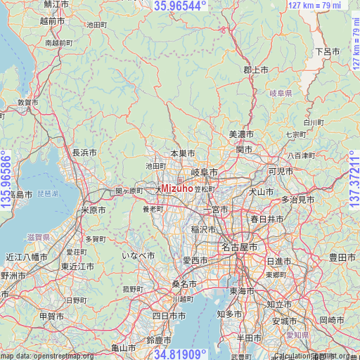
Mizuho GPS coordinates[2]
35° 23' 39.48" North, 136° 40' 8.328" East
| Map corner | latitude | longitude |
|---|---|---|
| Upper-left | 35.96544°, | 135.96586° |
| Center: | 35.3943°, | 136.66898° |
| Lower-right: | 34.81909°, | 137.37211° |
| Map W x H: | 127.5×127.5 km | = 79.2×79.2mi |
| max Lat: | 45.40944° ⇑49.4% North |
| Mizuho: | 35.3943° |
| min Lat: | ⇓50.6% South 24.34478° |
| min Long | Mizuho | max Long |
| 123° | 136.66898° | 145.575° |
| W 43.4%⇐ | ⇒56.6% E |
Elevation
Elevation of Mizuho is 7 m = 23 ft, and this is 77.6 m = 255 ft below average elevation for this country.
| Max E: |
1086 m = 3563 ft | 81.8% |
| Avg. | 84.6 m = 278 ft | |
| Mizuho | 7 m = 23 ft | |
Min E: |
-2 m = -7 ft | 18.2% |
See also: Japan elevation on elevation.city.
Geographical zone
Mizuho is located in North temperate zone (between Tropic of Cancer and the Arctic Circle). Distance of this Northern Tropic circle is 1329.6 km =826.2 mi to South.| Distance of | km | miles | from Mizuho |
|---|---|---|---|
| North Pole | 6071.6 | 3772.7 | to North |
| Arctic Circle | 3465.7 | 2153.5 | to North |
| Tropic Cancer | 1329.6 | 826.2 | to South |
| Equator | 3935.5 | 2445.4 | to South |


Nearby cities:
15 places around Mizuho: (largest is in red/bold)
• Gifu-shi
8.9 km =5.5 mi,  68°
68°
• Gōdo
6.7 km =4.2 mi,  291°
291°
• Hashima
7.3 km =4.5 mi,  171°
171°
• Ichinomiya
15.8 km =9.8 mi,  131°
131°
• Inazawa
19.1 km =11.9 mi,  147°
147°
• Iwakura
21.8 km =13.5 mi,  124°
124°
• Kaizu
21.6 km =13.4 mi,  188°
188°
• Kakamigahara
18.1 km =11.2 mi,  82°
82°
• Kasamatsuchō
9.4 km =5.8 mi,  109°
109°
• Kuroda
11.5 km =7.1 mi, 115°
• Kōnan
19.5 km =12.1 mi, 110°
• Motosu
10 km =6.2 mi,  2°
2°
• Sobue
16.6 km =10.3 mi,  164°
164°
• Tarui
12.7 km =7.9 mi,  255°
255°
• Ōgaki
6.8 km =4.2 mi,  223°
223°
Sources, notices
• [Note1] Compared only with cities in Japan existing in our database
• [Src1] Map data: © OpenStreetMap contributors (CC-BY-SA)
• [Src2] Other city data from geonames.org with taken over terms of usage.
• [Src3] Geographical zone / Annual Mean Temperature by Robert A. Rohde @ Wikipedia
