Ichinomiya geodata
Ichinomiya (Aichi) is a seat of a second-order administrative division; located in Japan in Asia/Tokyo (GMT+9) time zone. With population of 280,331 people, there are 73 cities with bigger population in this country. Compared to other cities in Japan, 52.2% of cities are located further ↑North; 54.9% of cities are located further →East and 71.1% of cities have higher elevation than Ichinomiya. Note1


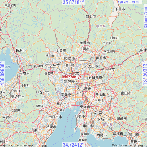
Ichinomiya GPS coordinates[2]
35° 18' 0" North, 136° 48' 0" East
| Map corner | latitude | longitude |
|---|---|---|
| Upper-left | 35.87181°, | 136.09688° |
| Center: | 35.3°, | 136.8° |
| Lower-right: | 34.72412°, | 137.50313° |
| Map W x H: | 127.6×127.6 km | = 79.3×79.3mi |
| max Lat: | 45.40944° ⇑52.2% North |
| Ichinomiya: | 35.3° |
| min Lat: | ⇓47.8% South 24.34478° |
| min Long | Ichinomiya | max Long |
| 123° | 136.8° | 145.575° |
| W 45.1%⇐ | ⇒54.9% E |
Elevation
Elevation of Ichinomiya is 11 m = 36 ft, and this is 73.6 m = 241 ft below average elevation for this country.
| Max E: |
1086 m = 3563 ft | 71.1% |
| Avg. | 84.6 m = 278 ft | |
| Ichinomiya | 11 m = 36 ft | |
Min E: |
-2 m = -7 ft | 28.9% |
See also: Ichinomiya elevation on elevation.city.
Geographical zone
Ichinomiya is located in North temperate zone (between Tropic of Cancer and the Arctic Circle). Distance of this Northern Tropic circle is 1319.1 km =819.7 mi to South.| Distance of | km | miles | from Ichinomiya |
|---|---|---|---|
| North Pole | 6082.1 | 3779.2 | to North |
| Arctic Circle | 3476.2 | 2160 | to North |
| Tropic Cancer | 1319.1 | 819.7 | to South |
| Equator | 3925 | 2438.9 | to South |


Nearby cities:
15 places around Ichinomiya: (largest is in red/bold)
• Ama
13 km =8.1 mi,  180°
180°
• Gifu-shi
14.1 km =8.8 mi,  345°
345°
• Hashima
11.3 km =7 mi,  286°
286°
• Inazawa
5.8 km =3.6 mi,  195°
195°
• Inuyama
15.7 km =9.8 mi,  55°
55°
• Iwakura
6.3 km =3.9 mi,  107°
107°
• Kakamigahara
14.3 km =8.9 mi,  24°
24°
• Kasamatsuchō
8 km =5 mi,  337°
337°
• Kitanagoya
9.2 km =5.7 mi,  129°
129°
• Kiyosu
9.7 km =6 mi,  161°
161°
• Komaki
10.7 km =6.6 mi,  99°
99°
• Kuroda
5.8 km =3.6 mi, 344°
• Kōnan
7.3 km =4.5 mi, 61°
• Mizuho
15.8 km =9.8 mi,  311°
311°
• Sobue
9.4 km =5.8 mi,  233°
233°
Sources, notices
• [Note1] Compared only with cities in Japan existing in our database
• [Src1] Map data: © OpenStreetMap contributors (CC-BY-SA)
• [Src2] Other city data from geonames.org with taken over terms of usage.
• [Src3] Geographical zone / Annual Mean Temperature by Robert A. Rohde @ Wikipedia
