Nomi geodata
Nomi (Ishikawa) is a seat of a second-order administrative division; located in Japan in Asia/Tokyo (GMT+9) time zone. In our database, there are 767 cities with bigger population. Compared to other cities in Japan, 76.3% of cities are located further ↓South; 57.9% of cities are located further →East and 69.4% of cities have lower elevation than Nomi. Note1


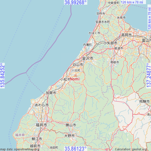
Nomi GPS coordinates[2]
36° 25' 44.472" North, 136° 32' 44.304" East
| Map corner | latitude | longitude |
|---|---|---|
| Upper-left | 36.99268°, | 135.84252° |
| Center: | 36.42902°, | 136.54564° |
| Lower-right: | 35.86123°, | 137.24877° |
| Map W x H: | 125.8×125.8 km | = 78.2×78.2mi |
| max Lat: | 45.40944° ⇑23.7% North |
| Nomi: | 36.42902° |
| min Lat: | ⇓76.3% South 24.34478° |
| min Long | Nomi | max Long |
| 123° | 136.54564° | 145.575° |
| W 42.1%⇐ | ⇒57.9% E |
Elevation
Elevation of Nomi is 70 m = 230 ft, and this is 14.6 m = 48 ft below average elevation for this country.
| Max E: |
1086 m = 3563 ft | 30.6% |
| Avg. | 84.6 m = 278 ft | |
| Nomi | 70 m = 230 ft | |
Min E: |
-2 m = -7 ft | 69.4% |
See also: Japan elevation on elevation.city.
Geographical zone
Nomi is located in North temperate zone (between Tropic of Cancer and the Arctic Circle). Distance of this Northern Tropic circle is 1444.6 km =897.6 mi to South.| Distance of | km | miles | from Nomi |
|---|---|---|---|
| North Pole | 5956.5 | 3701.2 | to North |
| Arctic Circle | 3350.6 | 2082 | to North |
| Tropic Cancer | 1444.6 | 897.6 | to South |
| Equator | 4050.5 | 2516.9 | to South |


Nearby cities:
15 places around Nomi: (largest is in red/bold)
• Awara
39.1 km =24.3 mi,  234°
234°
• Fukumitsu
32.3 km =20.1 mi,  63°
63°
• Hakusan
7 km =4.3 mi,  32°
32°
• Kaga
23.8 km =14.8 mi, 232°
• Kahoku
39.4 km =24.5 mi,  22°
22°
• Kanazawa
20 km =12.4 mi, 18°
• Komatsu
9 km =5.6 mi,  250°
250°
• Maruoka
39.3 km =24.4 mi,  218°
218°
• Matsutō
9.9 km =6.2 mi,  10°
10°
• Nanto
32.5 km =20.2 mi,  73°
73°
• Nanto-shi
36.2 km =22.5 mi, 64°
• Nonoichi
13.2 km =8.2 mi, 28°
• Oyabe
37.9 km =23.5 mi,  45°
45°
• Tsubata
32 km =19.9 mi, 32°
• Tsurugi-asahimachi
8.2 km =5.1 mi, 73°
Sources, notices
• [Note1] Compared only with cities in Japan existing in our database
• [Src1] Map data: © OpenStreetMap contributors (CC-BY-SA)
• [Src2] Other city data from geonames.org with taken over terms of usage.
• [Src3] Geographical zone / Annual Mean Temperature by Robert A. Rohde @ Wikipedia
