Inagi geodata
Inagi (Tokyo) is a seat of a second-order administrative division; located in Japan in Asia/Tokyo (GMT+9) time zone. In our database, there are 767 cities with bigger population. Compared to other cities in Japan, 55.7% of cities are located further ↓South; 68.7% of cities are located further ←West and 75.2% of cities have lower elevation than Inagi. Note1


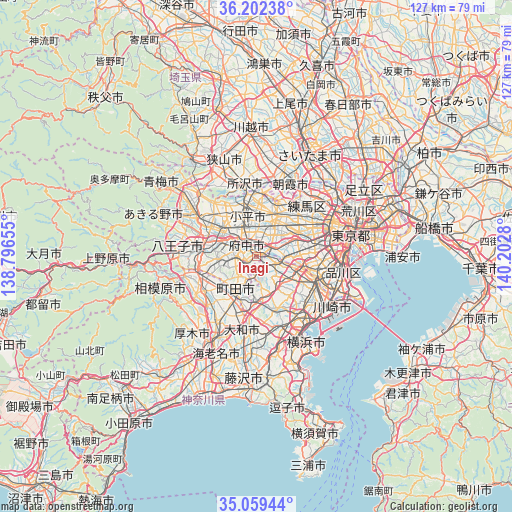
Inagi GPS coordinates[2]
35° 37' 58.62" North, 139° 29' 58.812" East
| Map corner | latitude | longitude |
|---|---|---|
| Upper-left | 36.20238°, | 138.79655° |
| Center: | 35.63295°, | 139.49967° |
| Lower-right: | 35.05944°, | 140.2028° |
| Map W x H: | 127.1×127.1 km | = 79×79mi |
| max Lat: | 45.40944° ⇑44.3% North |
| Inagi: | 35.63295° |
| min Lat: | ⇓55.7% South 24.34478° |
| min Long | Inagi | max Long |
| 123° | 139.49967° | 145.575° |
| W 68.7%⇐ | ⇒31.3% E |
Elevation
Elevation of Inagi is 96 m = 315 ft, and this is 11.4 m = 37 ft above average elevation for this country.
| Max E: |
1086 m = 3563 ft | 24.8% |
| Inagi | 96 m 315 ft | |
| Avg. | 84.6 m = 278 ft | |
Min E: |
-2 m = -7 ft | 75.2% |
See also: Japan elevation on elevation.city.
Geographical zone
Inagi is located in North temperate zone (between Tropic of Cancer and the Arctic Circle). Distance of this Northern Tropic circle is 1356.1 km =842.6 mi to South.| Distance of | km | miles | from Inagi |
|---|---|---|---|
| North Pole | 6045 | 3756.2 | to North |
| Arctic Circle | 3439.2 | 2137 | to North |
| Tropic Cancer | 1356.1 | 842.6 | to South |
| Equator | 3962 | 2461.9 | to South |


Nearby cities:
15 places around Inagi: (largest is in red/bold)
• Chōfu
5.3 km =3.3 mi,  56°
56°
• Fuchū
4.9 km =3 mi,  341°
341°
• Hino
10 km =6.2 mi,  296°
296°
• Kamirenjaku
8.4 km =5.2 mi,  36°
36°
• Kodaira
10.4 km =6.5 mi,  352°
352°
• Koganei
7.5 km =4.7 mi,  7°
7°
• Kokubunji
8 km =5 mi, 344°
• Komae
6.9 km =4.3 mi,  88°
88°
• Kunitachi
7.9 km =4.9 mi,  315°
315°
• Machida
11.2 km =7 mi,  203°
203°
• Mitaka
7.8 km =4.8 mi, 44°
• Musashino
9.8 km =6.1 mi,  33°
33°
• Nishi-Tokyo-shi
10.8 km =6.7 mi,  18°
18°
• Tachikawa
11.2 km =7 mi, 319°
• Tama
3.1 km =1.9 mi,  292°
292°
Sources, notices
• [Note1] Compared only with cities in Japan existing in our database
• [Src1] Map data: © OpenStreetMap contributors (CC-BY-SA)
• [Src2] Other city data from geonames.org with taken over terms of usage.
• [Src3] Geographical zone / Annual Mean Temperature by Robert A. Rohde @ Wikipedia
