Kasado geodata
Kasado (Mie) is a seat of a second-order administrative division; located in Japan in Asia/Tokyo (GMT+9) time zone. In our database, there are 767 cities with bigger population. Compared to other cities in Japan, 61.1% of cities are located further ↑North; 58.2% of cities are located further →East and 57.2% of cities have lower elevation than Kasado. Note1


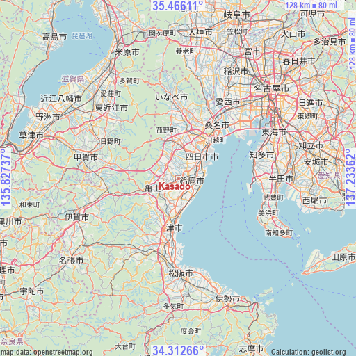
Kasado GPS coordinates[2]
34° 53' 29.076" North, 136° 31' 49.764" East
| Map corner | latitude | longitude |
|---|---|---|
| Upper-left | 35.46611°, | 135.82737° |
| Center: | 34.89141°, | 136.53049° |
| Lower-right: | 34.31266°, | 137.23362° |
| Map W x H: | 128.3×128.3 km | = 79.7×79.7mi |
| max Lat: | 45.40944° ⇑61.1% North |
| Kasado: | 34.89141° |
| min Lat: | ⇓38.9% South 24.34478° |
| min Long | Kasado | max Long |
| 123° | 136.53049° | 145.575° |
| W 41.8%⇐ | ⇒58.2% E |
Elevation
Elevation of Kasado is 40 m = 131 ft, and this is 44.6 m = 146 ft below average elevation for this country.
| Max E: |
1086 m = 3563 ft | 42.8% |
| Avg. | 84.6 m = 278 ft | |
| Kasado | 40 m = 131 ft | |
Min E: |
-2 m = -7 ft | 57.2% |
See also: Japan elevation on elevation.city.
Geographical zone
Kasado is located in North temperate zone (between Tropic of Cancer and the Arctic Circle). Distance of this Northern Tropic circle is 1273.6 km =791.4 mi to South.| Distance of | km | miles | from Kasado |
|---|---|---|---|
| North Pole | 6127.5 | 3807.5 | to North |
| Arctic Circle | 3521.6 | 2188.2 | to North |
| Tropic Cancer | 1273.6 | 791.4 | to South |
| Equator | 3879.6 | 2410.7 | to South |


Nearby cities:
15 places around Kasado: (largest is in red/bold)
• Chita
32.8 km =20.4 mi,  67°
67°
• Higashiōmi
34 km =21.1 mi,  314°
314°
• Hino
28.3 km =17.6 mi,  295°
295°
• Hisai-motomachi
25.7 km =16 mi,  193°
193°
• Inabe
25 km =15.5 mi,  8°
8°
• Kameyama
8.7 km =5.4 mi,  237°
237°
• Kawage
9.8 km =6.1 mi,  171°
171°
• Komono
12.1 km =7.5 mi,  354°
354°
• Kuwana
21.9 km =13.6 mi,  35°
35°
• Minakuchichō-matoba
34.2 km =21.3 mi,  284°
284°
• Suzuka
4.9 km =3 mi,  100°
100°
• Tokoname
29.2 km =18.1 mi,  91°
91°
• Tsu
17.6 km =10.9 mi,  184°
184°
• Yatomi
30.1 km =18.7 mi, 37°
• Yokkaichi
11.5 km =7.1 mi, 43°
Sources, notices
• [Note1] Compared only with cities in Japan existing in our database
• [Src1] Map data: © OpenStreetMap contributors (CC-BY-SA)
• [Src2] Other city data from geonames.org with taken over terms of usage.
• [Src3] Geographical zone / Annual Mean Temperature by Robert A. Rohde @ Wikipedia
