Buota Village geodata
Buota Village (Gilbert Islands) is a populated place; located in Kiribati in Pacific/Tarawa (GMT+12) time zone. With population of 1,373 people, there are 14 cities with bigger population in this country. Compared to other cities in Kiribati, 71.4% of cities are located further ↓South; 57.1% of cities are located further ←West and 60% of cities have lower elevation than Buota Village. Note1


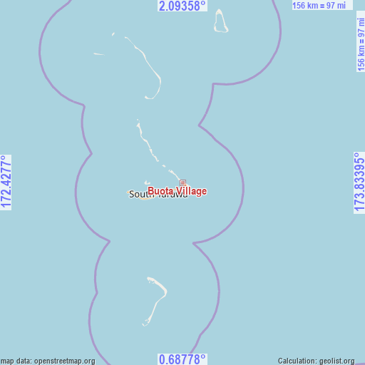
Buota Village GPS coordinates[2]
1° 23' 26.808" North, 173° 7' 50.952" East
| Map corner | latitude | longitude |
|---|---|---|
| Upper-left | 2.09358°, | 172.4277° |
| Center: | 1.39078°, | 173.13082° |
| Lower-right: | 0.68778°, | 173.83395° |
| Map W x H: | 156.3×156.3 km | = 97.1×97.1mi |
| max Lat: | 3.90806° ⇑28.6% North |
| Buota Village: | 1.39078° |
| min Lat: | ⇓71.4% South -2.65512° |
| min Long | Buota Village | max Long |
| -159.38832° | 173.13082° | 176.83302° |
| W 57.1%⇐ | ⇒42.9% E |
Elevation
Elevation of Buota Village is 11 m = 36 ft, and this is 1.1 m = 4 ft above average elevation for this country.
| Max E: |
13 m = 43 ft | 40% |
| Buota Village | 11 m 36 ft | |
| Avg. | 9.9 m = 32 ft | |
Min E: |
6 m = 20 ft | 60% |
See also: Kiribati elevation on elevation.city.
Geographical zone
Buota Village is located in North Torrid zone (between Equator and Tropic of Cancer). Distance of Equator is 154.6 km =96.1 mi to South.| Distance of | km | miles | from Buota Village |
|---|---|---|---|
| North Pole | 9852.4 | 6122 | to North |
| Arctic Circle | 7246.5 | 4502.8 | to North |
| Tropic Cancer | 2451.3 | 1523.2 | to North |
| Equator | 154.6 | 96.1 | to South |


Nearby cities:
15 places around Buota Village: (largest is in red/bold)
• Abarao Village
3.9 km =2.4 mi,  217°
217°
• Ambo Village
10.7 km =6.6 mi,  246°
246°
• Bairiki Village
18.6 km =11.6 mi, 248°
• Banraeaba Village
11.8 km =7.3 mi,  244°
244°
• Betio Village
23.6 km =14.7 mi,  261°
261°
• Bikenibeu Village
2.7 km =1.7 mi,  195°
195°
• Bonriki Village
1.4 km =0.9 mi,  141°
141°
• Eita Village
6.4 km =4 mi, 239°
• Nanikai Village
16.3 km =10.1 mi, 245°
• Nawerewere Village
3.2 km =2 mi,  162°
162°
• Taborio Village
9.4 km =5.8 mi, 245°
• Taborio Village
20.2 km =12.6 mi,  315°
315°
• Tarawa
18.5 km =11.5 mi, 247°
• Teaoraereke Village
14.7 km =9.1 mi, 244°
• Temaiku Village
4.7 km =2.9 mi,  131°
131°
Sources, notices
• [Note1] Compared only with cities in Kiribati existing in our database
• [Src1] Map data: © OpenStreetMap contributors (CC-BY-SA)
• [Src2] Other city data from geonames.org with taken over terms of usage.
• [Src3] Geographical zone / Annual Mean Temperature by Robert A. Rohde @ Wikipedia
