Taborio Village geodata
Taborio Village (Gilbert Islands) is a populated place; located in Kiribati in Pacific/Tarawa (GMT+12) time zone. With population of 955 people, there are 17 cities with bigger population in this country. Compared to other cities in Kiribati, 51.4% of cities are located further ↑North; 54.3% of cities are located further →East and 60% of cities have higher elevation than Taborio Village. Note1


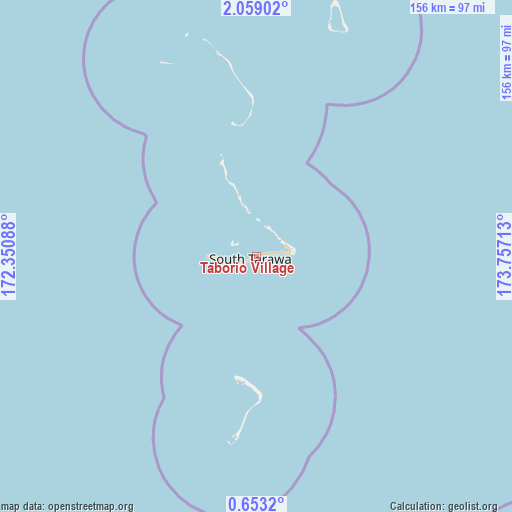
Taborio Village GPS coordinates[2]
1° 21' 22.356" North, 173° 3' 14.4" East
| Map corner | latitude | longitude |
|---|---|---|
| Upper-left | 2.05902°, | 172.35088° |
| Center: | 1.35621°, | 173.054° |
| Lower-right: | 0.6532°, | 173.75713° |
| Map W x H: | 156.3×156.3 km | = 97.1×97.1mi |
| max Lat: | 3.90806° ⇑51.4% North |
| Taborio Village: | 1.35621° |
| min Lat: | ⇓48.6% South -2.65512° |
| min Long | Taborio Village | max Long |
| -159.38832° | 173.054° | 176.83302° |
| W 45.7%⇐ | ⇒54.3% E |
Elevation
Elevation of Taborio Village is 10 m = 33 ft, and this is 0.1 m = 0 ft above average elevation for this country.
| Max E: |
13 m = 43 ft | 60% |
| Taborio Village | 10 m 33 ft | |
| Avg. | 9.9 m = 32 ft | |
Min E: |
6 m = 20 ft | 40% |
See also: Kiribati elevation on elevation.city.
Geographical zone
Taborio Village is located in North Torrid zone (between Equator and Tropic of Cancer). Distance of Equator is 150.8 km =93.7 mi to South.| Distance of | km | miles | from Taborio Village |
|---|---|---|---|
| North Pole | 9856.3 | 6124.4 | to North |
| Arctic Circle | 7250.4 | 4505.2 | to North |
| Tropic Cancer | 2455.1 | 1525.5 | to North |
| Equator | 150.8 | 93.7 | to South |


Nearby cities:
15 places around Taborio Village: (largest is in red/bold)
• Abarao Village
6.2 km =3.9 mi,  83°
83°
• Ambo Village
1.3 km =0.8 mi,  255°
255°
• Bairiki Village
9.3 km =5.8 mi,  251°
251°
• Banraeaba Village
2.5 km =1.6 mi,  240°
240°
• Betio Village
14.8 km =9.2 mi,  270°
270°
• Bikenibeu Village
7.9 km =4.9 mi, 81°
• Bonriki Village
9.8 km =6.1 mi,  73°
73°
• Buota Village
9.4 km =5.8 mi, 65°
• Eita Village
3.1 km =1.9 mi, 78°
• Nanikai Village
6.9 km =4.3 mi, 245°
• Nawerewere Village
9.5 km =5.9 mi,  85°
85°
• Taborio Village
19.1 km =11.9 mi,  342°
342°
• Tarawa
9.1 km =5.7 mi, 249°
• Teaoraereke Village
5.4 km =3.4 mi, 241°
• Temaiku Village
12.1 km =7.5 mi, 86°
Sources, notices
• [Note1] Compared only with cities in Kiribati existing in our database
• [Src1] Map data: © OpenStreetMap contributors (CC-BY-SA)
• [Src2] Other city data from geonames.org with taken over terms of usage.
• [Src3] Geographical zone / Annual Mean Temperature by Robert A. Rohde @ Wikipedia
