Domoni geodata
Domoni (Anjouan) is a populated place; located in Comoros in Indian/Comoro (GMT+3) time zone. With population of 14,509 people, there are 3 cities with bigger population in this country. Compared to other cities in Comoros, 81.4% of cities are located further ↑North; 100% of cities are located further ←West and 92.9% of cities have higher elevation than Domoni. Note1


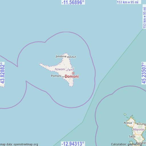
Domoni GPS coordinates[2]
12° 15' 24.984" South, 44° 31' 54.984" East
| Map corner | latitude | longitude |
|---|---|---|
| Upper-left | -11.56896°, | 43.82882° |
| Center: | -12.25694°, | 44.53194° |
| Lower-right: | -12.94313°, | 45.23507° |
| Map W x H: | 152.8×152.8 km | = 94.9×94.9mi |
| max Lat: | -11.38472° ⇑81.4% North |
| Domoni: | -12.25694° |
| min Lat: | ⇓18.6% South -12.37306° |
| min Long | Domoni | max Long |
| 43.2525° | 44.53194° | 44.53194° |
| W 100%⇐ | ⇒0% E |
Elevation
Elevation of Domoni is 18 m = 59 ft, and this is 178.1 m = 584 ft below average elevation for this country.
| Max E: |
924 m = 3031 ft | 92.9% |
| Avg. | 196.1 m = 643 ft | |
| Domoni | 18 m = 59 ft | |
Min E: |
1 m = 3 ft | 7.1% |
See also: Comoros elevation on elevation.city.
Geographical zone
Domoni is located in South Torrid zone (between Equator and Tropic of Capricorn). Distance of this Southern Tropic circle is 1243.1 km =772.4 mi to South.| Distance of | km | miles | from Domoni |
|---|---|---|---|
| Equator | 1362.8 | 846.8 | to North |
| Tropic Capricorn | 1243.1 | 772.4 | to South |
| Antarctic Circle | 6038.3 | 3752 | to South |
| South Pole | 8644.2 | 5371.3 | to South |


Nearby cities:
15 places around Domoni: (largest is in red/bold)
• Adda-Douéni
5.5 km =3.4 mi,  223°
223°
• Bambao
6.2 km =3.9 mi,  344°
344°
• Chandra
10 km =6.2 mi,  313°
313°
• Daji
9 km =5.6 mi,  211°
211°
• Dziani
9.7 km =6 mi,  327°
327°
• Kangani
9.6 km =6 mi, 222°
• Koni-Djodjo
6.2 km =3.9 mi,  298°
298°
• Koni-Ngani
7.3 km =4.5 mi, 309°
• Kyo
8.5 km =5.3 mi,  189°
189°
• Limbi
3.5 km =2.2 mi, 303°
• Mramani
10 km =6.2 mi,  182°
182°
• Mrémani
6.8 km =4.2 mi, 212°
• Ongoni
10 km =6.2 mi, 344°
• Ouzini
5.8 km =3.6 mi,  258°
258°
• Tsimbeo
9.3 km =5.8 mi, 307°
Sources, notices
• [Note1] Compared only with cities in Comoros existing in our database
• [Src1] Map data: © OpenStreetMap contributors (CC-BY-SA)
• [Src2] Other city data from geonames.org with taken over terms of usage.
• [Src3] Geographical zone / Annual Mean Temperature by Robert A. Rohde @ Wikipedia
