Dziani geodata
Dziani (Anjouan) is a populated place; located in Comoros in Indian/Comoro (GMT+3) time zone. With population of 1,754 people, there are 57 cities with bigger population in this country. Compared to other cities in Comoros, 60.2% of cities are located further ↑North; 89.4% of cities are located further ←West and 77.9% of cities have lower elevation than Dziani. Note1


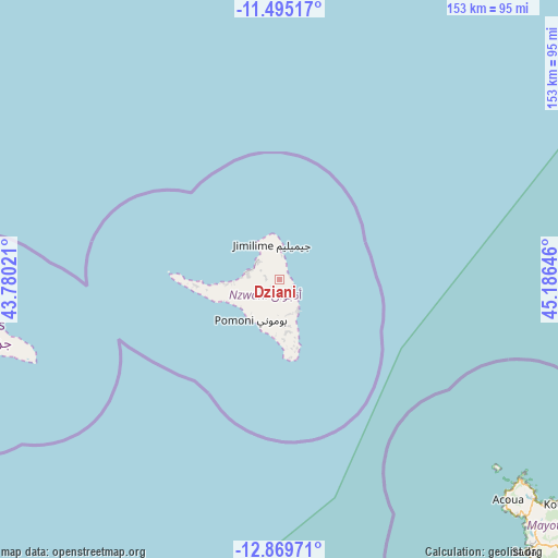
Dziani GPS coordinates[2]
12° 10' 59.988" South, 44° 28' 59.988" East
| Map corner | latitude | longitude |
|---|---|---|
| Upper-left | -11.49517°, | 43.78021° |
| Center: | -12.18333°, | 44.48333° |
| Lower-right: | -12.86971°, | 45.18646° |
| Map W x H: | 152.8×152.8 km | = 94.9×94.9mi |
| max Lat: | -11.38472° ⇑60.2% North |
| Dziani: | -12.18333° |
| min Lat: | ⇓39.8% South -12.37306° |
| min Long | Dziani | max Long |
| 43.2525° | 44.48333° | 44.53194° |
| W 89.4%⇐ | ⇒10.6% E |
Elevation
Elevation of Dziani is 289 m = 948 ft, and this is 92.9 m = 305 ft above average elevation for this country.
| Max E: |
924 m = 3031 ft | 22.1% |
| Dziani | 289 m 948 ft | |
| Avg. | 196.1 m = 643 ft | |
Min E: |
1 m = 3 ft | 77.9% |
See also: Comoros elevation on elevation.city.
Geographical zone
Dziani is located in South Torrid zone (between Equator and Tropic of Capricorn). Distance of this Southern Tropic circle is 1251.3 km =777.5 mi to South.| Distance of | km | miles | from Dziani |
|---|---|---|---|
| Equator | 1354.7 | 841.8 | to North |
| Tropic Capricorn | 1251.3 | 777.5 | to South |
| Antarctic Circle | 6046.5 | 3757.1 | to South |
| South Pole | 8652.4 | 5376.4 | to South |


Nearby cities:
15 places around Dziani: (largest is in red/bold)
• Bambao
4.2 km =2.6 mi,  121°
121°
• Barakani
7.6 km =4.7 mi,  310°
310°
• Chandra
2.4 km =1.5 mi,  237°
237°
• Hajoho
6.6 km =4.1 mi,  5°
5°
• Harembo
3.9 km =2.4 mi,  24°
24°
• Koki
4.7 km =2.9 mi,  286°
286°
• Koni-Djodjo
5.2 km =3.2 mi,  182°
182°
• Koni-Ngani
3.6 km =2.2 mi,  185°
185°
• Limbi
6.7 km =4.2 mi,  159°
159°
• Mirontsi
8.7 km =5.4 mi, 289°
• Ongoni
2.9 km =1.8 mi,  60°
60°
• Ouani
8.3 km =5.2 mi, 309°
• Ouzini
9.3 km =5.8 mi, 182°
• Patsi
5.9 km =3.7 mi,  301°
301°
• Tsimbeo
3.2 km =2 mi,  218°
218°
Sources, notices
• [Note1] Compared only with cities in Comoros existing in our database
• [Src1] Map data: © OpenStreetMap contributors (CC-BY-SA)
• [Src2] Other city data from geonames.org with taken over terms of usage.
• [Src3] Geographical zone / Annual Mean Temperature by Robert A. Rohde @ Wikipedia
