Jinwol geodata
Jinwol (Jeollanam-do) is a seat of a third-order administrative division; located in South Korea in Asia/Seoul (GMT+9) time zone. In our database, there are 128 cities with bigger population. Compared to other cities in South Korea, 81.8% of cities are located further ↑North; 72.4% of cities are located further ←West and 93.4% of cities have higher elevation than Jinwol. Note1


Jinwol GPS coordinates[2]
34° 58' 44.76" North, 127° 45' 29.052" East
| Map corner | latitude | longitude |
|---|---|---|
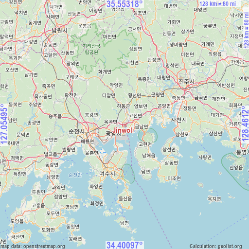
| Upper-left | 35.55318°, | 127.05495° |
| Center: | 34.9791°, | 127.75807° |
| Lower-right: | 34.40097°, | 128.4612° |
| Map W x H: | 128.1×128.1 km | = 79.6×79.6mi |
| max Lat: | 38.37881° ⇑81.8% North |
| Jinwol: | 34.9791° |
| min Lat: | ⇓18.2% South 33.25333° |
| min Long | Jinwol | max Long |
| 126.10863° | 127.75807° | 129.55377° |
| W 72.4%⇐ | ⇒27.6% E |
Elevation
Elevation of Jinwol is 8 m = 26 ft, and this is 62.4 m = 205 ft below average elevation for this country.
| Max E: |
691 m = 2267 ft | 93.4% |
| Avg. | 70.4 m = 231 ft | |
| Jinwol | 8 m = 26 ft | |
Min E: |
1 m = 3 ft | 6.6% |
See also: South Korea elevation on elevation.city.
Geographical zone
Jinwol is located in North temperate zone (between Tropic of Cancer and the Arctic Circle). Distance of this Northern Tropic circle is 1283.4 km =797.5 mi to South.| Distance of | km | miles | from Jinwol |
|---|---|---|---|
| North Pole | 6117.8 | 3801.4 | to North |
| Arctic Circle | 3511.9 | 2182.2 | to North |
| Tropic Cancer | 1283.4 | 797.5 | to South |
| Equator | 3889.3 | 2416.7 | to South |


Nearby cities:
15 places around Jinwol: (largest is in red/bold)
• Bonggang
16.5 km =10.3 mi,  282°
282°
• Geumseong
3.4 km =2.1 mi,  118°
118°
• Gwangyang
7.1 km =4.4 mi,  233°
233°
• Hadong
9.9 km =6.2 mi,  356°
356°
• Haeryong
21.4 km =13.3 mi,  250°
250°
• Jeongnyang
11.7 km =7.3 mi,  8°
8°
• Jinsang
5.8 km =3.6 mi,  323°
323°
• Kwangyang
15.4 km =9.6 mi,  268°
268°
• Nammyeon
25.8 km =16 mi,  152°
152°
• Okgok
5.5 km =3.4 mi, 282°
• Ongnyong
13.4 km =8.3 mi,  288°
288°
• Sora
23.6 km =14.7 mi,  209°
209°
• Suncheon
24.8 km =15.4 mi,  262°
262°
• Yeosu
25.8 km =16 mi,  199°
199°
• Yulchon
19.6 km =12.2 mi,  236°
236°
Sources, notices
• [Note1] Compared only with cities in South Korea existing in our database
• [Src1] Map data: © OpenStreetMap contributors (CC-BY-SA)
• [Src2] Other city data from geonames.org with taken over terms of usage.
• [Src3] Geographical zone / Annual Mean Temperature by Robert A. Rohde @ Wikipedia
