Koch'ang geodata
Koch'ang (Jeollabuk-do) is a populated place; located in South Korea in Asia/Seoul (GMT+9) time zone. With population of 72,996 people, there are 66 cities with bigger population in this country. Compared to other cities in South Korea, 63.6% of cities are located further ↑North; 81.1% of cities are located further →East and 51% of cities have lower elevation than Koch'ang. Note1


Koch'ang GPS coordinates[2]
35° 25' 59.988" North, 126° 42' 0" East
| Map corner | latitude | longitude |
|---|---|---|
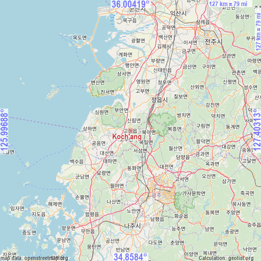
| Upper-left | 36.00419°, | 125.99688° |
| Center: | 35.43333°, | 126.7° |
| Lower-right: | 34.8584°, | 127.40313° |
| Map W x H: | 127.4×127.4 km | = 79.2×79.2mi |
| max Lat: | 38.37881° ⇑63.6% North |
| Koch'ang: | 35.43333° |
| min Lat: | ⇓36.4% South 33.25333° |
| min Long | Koch'ang | max Long |
| 126.10863° | 126.7° | 129.55377° |
| W 18.9%⇐ | ⇒81.1% E |
Elevation
Elevation of Koch'ang is 44 m = 144 ft, and this is 26.4 m = 87 ft below average elevation for this country.
| Max E: |
691 m = 2267 ft | 49% |
| Avg. | 70.4 m = 231 ft | |
| Koch'ang | 44 m = 144 ft | |
Min E: |
1 m = 3 ft | 51% |
See also: Koch'ang elevation on elevation.city.
Geographical zone
Koch'ang is located in North temperate zone (between Tropic of Cancer and the Arctic Circle). Distance of this Northern Tropic circle is 1333.9 km =828.8 mi to South.| Distance of | km | miles | from Koch'ang |
|---|---|---|---|
| North Pole | 6067.2 | 3770 | to North |
| Arctic Circle | 3461.4 | 2150.8 | to North |
| Tropic Cancer | 1333.9 | 828.8 | to South |
| Equator | 3939.8 | 2448.1 | to South |


Nearby cities:
15 places around Koch'ang: (largest is in red/bold)
• Beopseong
24.3 km =15.1 mi,  251°
251°
• Daema
18.4 km =11.4 mi,  217°
217°
• Daesan
13.4 km =8.3 mi, 220°
• Damyang
28.7 km =17.8 mi,  116°
116°
• Gongeum
18.2 km =11.3 mi, 250°
• Gunseo
28.2 km =17.5 mi,  226°
226°
• Haeri
14.9 km =9.3 mi,  282°
282°
• Hongnong
23.5 km =14.6 mi,  259°
259°
• Jangseong
16.9 km =10.5 mi,  153°
153°
• Jeongeup
27 km =16.8 mi,  46°
46°
• Myoryang
24.2 km =15 mi, 216°
• Sangha
18.6 km =11.6 mi,  273°
273°
• Simwon
16.9 km =10.5 mi,  306°
306°
• Ssangchi
28.5 km =17.7 mi,  74°
74°
• Yeonggwang
24.3 km =15.1 mi, 224°
Sources, notices
• [Note1] Compared only with cities in South Korea existing in our database
• [Src1] Map data: © OpenStreetMap contributors (CC-BY-SA)
• [Src2] Other city data from geonames.org with taken over terms of usage.
• [Src3] Geographical zone / Annual Mean Temperature by Robert A. Rohde @ Wikipedia
