Damyang geodata
Damyang (Jeollanam-do) is a seat of a second-order administrative division; located in South Korea in Asia/Seoul (GMT+9) time zone. In our database, there are 128 cities with bigger population. Compared to other cities in South Korea, 66.8% of cities are located further ↑North; 67.5% of cities are located further →East and 55.9% of cities have lower elevation than Damyang. Note1


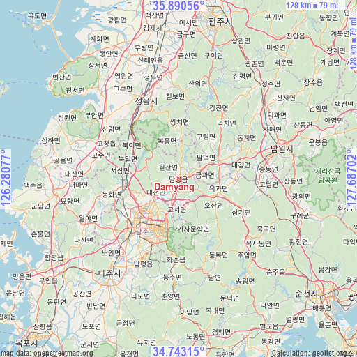
Damyang GPS coordinates[2]
35° 19' 8.004" North, 126° 59' 2.004" East
| Map corner | latitude | longitude |
|---|---|---|
| Upper-left | 35.89056°, | 126.28077° |
| Center: | 35.31889°, | 126.98389° |
| Lower-right: | 34.74315°, | 127.68702° |
| Map W x H: | 127.6×127.6 km | = 79.3×79.3mi |
| max Lat: | 38.37881° ⇑66.8% North |
| Damyang: | 35.31889° |
| min Lat: | ⇓33.2% South 33.25333° |
| min Long | Damyang | max Long |
| 126.10863° | 126.98389° | 129.55377° |
| W 32.5%⇐ | ⇒67.5% E |
Elevation
Elevation of Damyang is 49 m = 161 ft, and this is 21.4 m = 70 ft below average elevation for this country.
| Max E: |
691 m = 2267 ft | 44.1% |
| Avg. | 70.4 m = 231 ft | |
| Damyang | 49 m = 161 ft | |
Min E: |
1 m = 3 ft | 55.9% |
See also: South Korea elevation on elevation.city.
Geographical zone
Damyang is located in North temperate zone (between Tropic of Cancer and the Arctic Circle). Distance of this Northern Tropic circle is 1321.2 km =821 mi to South.| Distance of | km | miles | from Damyang |
|---|---|---|---|
| North Pole | 6080 | 3777.9 | to North |
| Arctic Circle | 3474.1 | 2158.7 | to North |
| Tropic Cancer | 1321.2 | 821 | to South |
| Equator | 3927.1 | 2440.2 | to South |


Nearby cities:
15 places around Damyang: (largest is in red/bold)
• Changpyeong
9.4 km =5.8 mi,  160°
160°
• Chilbo
31.6 km =19.6 mi,  1°
1°
• Dongbok
30.7 km =19.1 mi,  154°
154°
• Donggye
27.1 km =16.8 mi,  59°
59°
• Gangjin
28.6 km =17.8 mi,  34°
34°
• Gurim
18.4 km =11.4 mi,  35°
35°
• Gwangju
19.3 km =12 mi,  198°
198°
• Hwasun
28.6 km =17.8 mi,  179°
179°
• Ingye
17.7 km =11 mi,  53°
53°
• Jangseong
18.2 km =11.3 mi,  262°
262°
• Jeongeup
31.8 km =19.8 mi,  349°
349°
• Koch'ang
28.7 km =17.8 mi,  296°
296°
• Masan
25.4 km =15.8 mi,  213°
213°
• Sannae
28 km =17.4 mi,  8°
8°
• Ssangchi
20.4 km =12.7 mi, 4°
Sources, notices
• [Note1] Compared only with cities in South Korea existing in our database
• [Src1] Map data: © OpenStreetMap contributors (CC-BY-SA)
• [Src2] Other city data from geonames.org with taken over terms of usage.
• [Src3] Geographical zone / Annual Mean Temperature by Robert A. Rohde @ Wikipedia
