Ganghwa-gun geodata
Ganghwa-gun (Incheon) is a seat of a third-order administrative division; located in South Korea in Asia/Seoul (GMT+9) time zone. With population of 25,535 people, there are 109 cities with bigger population in this country. Compared to other cities in South Korea, 89.9% of cities are located further ↓South; 90.9% of cities are located further →East and 81.8% of cities have higher elevation than Ganghwa-gun. Note1


Ganghwa-gun GPS coordinates[2]
37° 44' 49.992" North, 126° 29' 8.016" East
| Map corner | latitude | longitude |
|---|---|---|
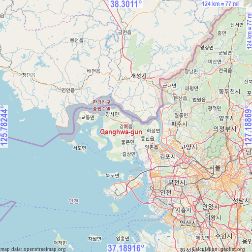
| Upper-left | 38.3011°, | 125.78244° |
| Center: | 37.74722°, | 126.48556° |
| Lower-right: | 37.18916°, | 127.18869° |
| Map W x H: | 123.6×123.6 km | = 76.8×76.8mi |
| max Lat: | 38.37881° ⇑10.1% North |
| Ganghwa-gun: | 37.74722° |
| min Lat: | ⇓89.9% South 33.25333° |
| min Long | Ganghwa-gun | max Long |
| 126.10863° | 126.48556° | 129.55377° |
| W 9.1%⇐ | ⇒90.9% E |
Elevation
Elevation of Ganghwa-gun is 15 m = 49 ft, and this is 55.4 m = 182 ft below average elevation for this country.
| Max E: |
691 m = 2267 ft | 81.8% |
| Avg. | 70.4 m = 231 ft | |
| Ganghwa-gun | 15 m = 49 ft | |
Min E: |
1 m = 3 ft | 18.2% |
See also: South Korea elevation on elevation.city.
Geographical zone
Ganghwa-gun is located in North temperate zone (between Tropic of Cancer and the Arctic Circle). Distance of this Northern Tropic circle is 1591.2 km =988.7 mi to South.| Distance of | km | miles | from Ganghwa-gun |
|---|---|---|---|
| North Pole | 5810 | 3610.2 | to North |
| Arctic Circle | 3204.1 | 1990.9 | to North |
| Tropic Cancer | 1591.2 | 988.7 | to South |
| Equator | 4197.1 | 2608 | to South |


Nearby cities:
15 places around Ganghwa-gun: (largest is in red/bold)
• Goyang-si
32.4 km =20.1 mi,  108°
108°
• Gwangtan
32.3 km =20.1 mi,  83°
83°
• Gyodong
18.4 km =11.4 mi,  282°
282°
• Hajeom
7.1 km =4.4 mi,  294°
294°
• Haseong
13.2 km =8.2 mi,  103°
103°
• Munsan
29.1 km =18.1 mi,  64°
64°
• Paju
30.6 km =19 mi,  71°
71°
• Samsan
15.3 km =9.5 mi,  251°
251°
• Seogeom-ri
22.4 km =13.9 mi,  261°
261°
• Seonwon
3.9 km =2.4 mi,  181°
181°
• Songhae
2.5 km =1.6 mi,  316°
316°
• Tanhyeon
21.2 km =13.2 mi, 73°
• Tongjin
11.7 km =7.3 mi,  121°
121°
• Wolgot
6.9 km =4.3 mi, 119°
• Yangsa
8.9 km =5.5 mi,  310°
310°
Sources, notices
• [Note1] Compared only with cities in South Korea existing in our database
• [Src1] Map data: © OpenStreetMap contributors (CC-BY-SA)
• [Src2] Other city data from geonames.org with taken over terms of usage.
• [Src3] Geographical zone / Annual Mean Temperature by Robert A. Rohde @ Wikipedia
