Jido geodata
Jido (Jeollanam-do) is a seat of a third-order administrative division; located in South Korea in Asia/Seoul (GMT+9) time zone. In our database, there are 128 cities with bigger population. Compared to other cities in South Korea, 78% of cities are located further ↑North; 98.6% of cities are located further →East and 95.1% of cities have higher elevation than Jido. Note1


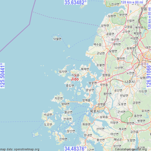
Jido GPS coordinates[2]
35° 3' 40.752" North, 126° 12' 27.108" East
| Map corner | latitude | longitude |
|---|---|---|
| Upper-left | 35.63482°, | 125.50441° |
| Center: | 35.06132°, | 126.20753° |
| Lower-right: | 34.48376°, | 126.91066° |
| Map W x H: | 128×128 km | = 79.5×79.5mi |
| max Lat: | 38.37881° ⇑78% North |
| Jido: | 35.06132° |
| min Lat: | ⇓22% South 33.25333° |
| min Long | Jido | max Long |
| 126.10863° | 126.20753° | 129.55377° |
| W 1.4%⇐ | ⇒98.6% E |
Elevation
Elevation of Jido is 7 m = 23 ft, and this is 63.4 m = 208 ft below average elevation for this country.
| Max E: |
691 m = 2267 ft | 95.1% |
| Avg. | 70.4 m = 231 ft | |
| Jido | 7 m = 23 ft | |
Min E: |
1 m = 3 ft | 4.9% |
See also: South Korea elevation on elevation.city.
Geographical zone
Jido is located in North temperate zone (between Tropic of Cancer and the Arctic Circle). Distance of this Northern Tropic circle is 1292.5 km =803.1 mi to South.| Distance of | km | miles | from Jido |
|---|---|---|---|
| North Pole | 6108.6 | 3795.7 | to North |
| Arctic Circle | 3502.7 | 2176.5 | to North |
| Tropic Cancer | 1292.5 | 803.1 | to South |
| Equator | 3898.5 | 2422.4 | to South |


Nearby cities:
15 places around Jido: (largest is in red/bold)
• Apae
23.7 km =14.7 mi,  156°
156°
• Baeksu
31.4 km =19.5 mi,  38°
38°
• Bulgap
31.9 km =19.8 mi,  58°
58°
• Gunnam
29.9 km =18.6 mi,  48°
48°
• Gunseo
32.8 km =20.4 mi, 47°
• Haeje
9.6 km =6 mi, 55°
• Illo
34.6 km =21.5 mi,  132°
132°
• Imja
9.2 km =5.7 mi,  286°
286°
• Mokpo
32.3 km =20.1 mi,  148°
148°
• Muan
26 km =16.2 mi,  107°
107°
• Nagwol
16.9 km =10.5 mi,  337°
337°
• Palgeum
31.2 km =19.4 mi,  190°
190°
• Sinan
27.7 km =17.2 mi,  199°
199°
• Sinan
28.5 km =17.7 mi, 152°
• Yeomsan
23 km =14.3 mi, 40°
Sources, notices
• [Note1] Compared only with cities in South Korea existing in our database
• [Src1] Map data: © OpenStreetMap contributors (CC-BY-SA)
• [Src2] Other city data from geonames.org with taken over terms of usage.
• [Src3] Geographical zone / Annual Mean Temperature by Robert A. Rohde @ Wikipedia
