Muan geodata
Muan (Jeollanam-do) is a seat of a first-order administrative division; located in South Korea in Asia/Seoul (GMT+9) time zone. With population of 75,718 people, there are 62 cities with bigger population in this country. Compared to other cities in South Korea, 81.5% of cities are located further ↑North; 91.6% of cities are located further →East and 71% of cities have higher elevation than Muan. Note1


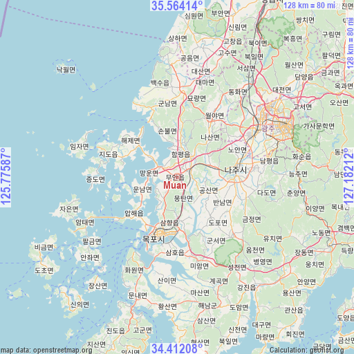
Muan GPS coordinates[2]
34° 59' 24.504" North, 126° 28' 44.364" East
| Map corner | latitude | longitude |
|---|---|---|
| Upper-left | 35.56414°, | 125.77587° |
| Center: | 34.99014°, | 126.47899° |
| Lower-right: | 34.41208°, | 127.18212° |
| Map W x H: | 128.1×128.1 km | = 79.6×79.6mi |
| max Lat: | 38.37881° ⇑81.5% North |
| Muan: | 34.99014° |
| min Lat: | ⇓18.5% South 33.25333° |
| min Long | Muan | max Long |
| 126.10863° | 126.47899° | 129.55377° |
| W 8.4%⇐ | ⇒91.6% E |
Elevation
Elevation of Muan is 21 m = 69 ft, and this is 49.4 m = 162 ft below average elevation for this country.
| Max E: |
691 m = 2267 ft | 71% |
| Avg. | 70.4 m = 231 ft | |
| Muan | 21 m = 69 ft | |
Min E: |
1 m = 3 ft | 29% |
See also: Muan elevation on elevation.city.
Geographical zone
Muan is located in North temperate zone (between Tropic of Cancer and the Arctic Circle). Distance of this Northern Tropic circle is 1284.6 km =798.2 mi to South.| Distance of | km | miles | from Muan |
|---|---|---|---|
| North Pole | 6116.5 | 3800.6 | to North |
| Arctic Circle | 3510.6 | 2181.4 | to North |
| Tropic Cancer | 1284.6 | 798.2 | to South |
| Equator | 3890.5 | 2417.4 | to South |


Nearby cities:
15 places around Muan: (largest is in red/bold)
• Apae
20.4 km =12.7 mi,  227°
227°
• Bannam
18.4 km =11.4 mi,  121°
121°
• Bulgap
24.5 km =15.2 mi,  6°
6°
• Dopo
22 km =13.7 mi,  136°
136°
• Haebo
24 km =14.9 mi,  27°
27°
• Haeje
21.5 km =13.4 mi,  308°
308°
• Illo
15.3 km =9.5 mi,  176°
176°
• Jido
26 km =16.2 mi,  287°
287°
• Mokpo
21.3 km =13.2 mi,  201°
201°
• Naju
22.2 km =13.8 mi,  78°
78°
• Nasan
18.2 km =11.3 mi,  40°
40°
• Seji
25.8 km =16 mi,  107°
107°
• Sijong
17.8 km =11.1 mi, 139°
• Sinan
20.9 km =13 mi,  213°
213°
• Yeomsan
27.2 km =16.9 mi,  339°
339°
Sources, notices
• [Note1] Compared only with cities in South Korea existing in our database
• [Src1] Map data: © OpenStreetMap contributors (CC-BY-SA)
• [Src2] Other city data from geonames.org with taken over terms of usage.
• [Src3] Geographical zone / Annual Mean Temperature by Robert A. Rohde @ Wikipedia
