Mokpo geodata
Mokpo (Jeollanam-do) is a seat of a second-order administrative division; located in South Korea in Asia/Seoul (GMT+9) time zone. With population of 268,402 people, there are 28 cities with bigger population in this country. Compared to other cities in South Korea, 93.4% of cities are located further ↑North; 95.5% of cities are located further →East and 54.5% of cities have lower elevation than Mokpo. Note1


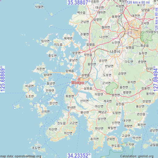
Mokpo GPS coordinates[2]
34° 48' 46.152" North, 126° 23' 30.516" East
| Map corner | latitude | longitude |
|---|---|---|
| Upper-left | 35.38807°, | 125.68869° |
| Center: | 34.81282°, | 126.39181° |
| Lower-right: | 34.23352°, | 127.09494° |
| Map W x H: | 128.4×128.4 km | = 79.8×79.8mi |
| max Lat: | 38.37881° ⇑93.4% North |
| Mokpo: | 34.81282° |
| min Lat: | ⇓6.6% South 33.25333° |
| min Long | Mokpo | max Long |
| 126.10863° | 126.39181° | 129.55377° |
| W 4.5%⇐ | ⇒95.5% E |
Elevation
Elevation of Mokpo is 48 m = 157 ft, and this is 22.4 m = 73 ft below average elevation for this country.
| Max E: |
691 m = 2267 ft | 45.5% |
| Avg. | 70.4 m = 231 ft | |
| Mokpo | 48 m = 157 ft | |
Min E: |
1 m = 3 ft | 54.5% |
See also: Mokpo elevation on elevation.city.
Geographical zone
Mokpo is located in North temperate zone (between Tropic of Cancer and the Arctic Circle). Distance of this Northern Tropic circle is 1264.9 km =786 mi to South.| Distance of | km | miles | from Mokpo |
|---|---|---|---|
| North Pole | 6136.2 | 3812.9 | to North |
| Arctic Circle | 3530.4 | 2193.7 | to North |
| Tropic Cancer | 1264.9 | 786 | to South |
| Equator | 3870.8 | 2405.2 | to South |


Nearby cities:
15 places around Mokpo: (largest is in red/bold)
• Apae
9.4 km =5.8 mi,  309°
309°
• Bannam
25.8 km =16 mi,  66°
66°
• Deokjin
27.9 km =17.3 mi,  88°
88°
• Dopo
23.3 km =14.5 mi,  80°
80°
• Geumjeong
33.1 km =20.6 mi, 80°
• Haeje
34.3 km =21.3 mi,  345°
345°
• Haenam
32.9 km =20.4 mi,  144°
144°
• Illo
10 km =6.2 mi,  63°
63°
• Jido
32.3 km =20.1 mi,  328°
328°
• Muan
21.3 km =13.2 mi,  21°
21°
• Palgeum
22.9 km =14.2 mi,  262°
262°
• Sijong
20.6 km =12.8 mi, 72°
• Sinan
4.4 km =2.7 mi,  302°
302°
• Sinan
25.9 km =16.1 mi,  273°
273°
• Yeongam
27.9 km =17.3 mi, 92°
Sources, notices
• [Note1] Compared only with cities in South Korea existing in our database
• [Src1] Map data: © OpenStreetMap contributors (CC-BY-SA)
• [Src2] Other city data from geonames.org with taken over terms of usage.
• [Src3] Geographical zone / Annual Mean Temperature by Robert A. Rohde @ Wikipedia
