Ḩawallī geodata
Ḩawallī (Hawalli) is a seat of a first-order administrative division; located in Kuwait in Asia/Kuwait (GMT+3) time zone. With population of 164,212 people, there is 1 city with bigger population in this country. Compared to other cities in Kuwait, 76% of cities are located further ↓South; 68% of cities are located further →East and 60% of cities have lower elevation than Ḩawallī. Note1


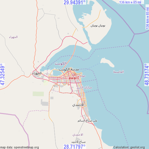
Ḩawallī GPS coordinates[2]
29° 19' 58.008" North, 48° 1' 42.996" East
| Map corner | latitude | longitude |
|---|---|---|
| Upper-left | 29.94391°, | 47.32549° |
| Center: | 29.33278°, | 48.02861° |
| Lower-right: | 28.71797°, | 48.73174° |
| Map W x H: | 136.3×136.3 km | = 84.7×84.7mi |
| max Lat: | 29.4425° ⇑24% North |
| Ḩawallī: | 29.33278° |
| min Lat: | ⇓76% South 28.63917° |
| min Long | Ḩawallī | max Long |
| 47.65806° | 48.02861° | 48.27472° |
| W 32%⇐ | ⇒68% E |
Elevation
Elevation of Ḩawallī is 19 m = 62 ft, and this is 7.7 m = 25 ft below average elevation for this country.
| Max E: |
164 m = 538 ft | 40% |
| Avg. | 26.7 m = 88 ft | |
| Ḩawallī | 19 m = 62 ft | |
Min E: |
4 m = 13 ft | 60% |
See also: Ḩawallī elevation on elevation.city.
Geographical zone
Ḩawallī is located in North temperate zone (between Tropic of Cancer and the Arctic Circle). Distance of this Northern Tropic circle is 655.6 km =407.4 mi to South.| Distance of | km | miles | from Ḩawallī |
|---|---|---|---|
| North Pole | 6745.6 | 4191.5 | to North |
| Arctic Circle | 4139.7 | 2572.3 | to North |
| Tropic Cancer | 655.6 | 407.4 | to South |
| Equator | 3261.5 | 2026.6 | to South |


Nearby cities:
15 places around Ḩawallī: (largest is in red/bold)
• Abu Fatira
16.7 km =10.4 mi,  154°
154°
• Ad Dasmah
4.4 km =2.7 mi,  323°
323°
• Al Farwānīyah
9.2 km =5.7 mi,  227°
227°
• Al Funayţīs
13.9 km =8.6 mi, 149°
• Al-Masayel
11.9 km =7.4 mi, 150°
• Ar Rumaythīyah
5 km =3.1 mi,  117°
117°
• Ar Rābiyah
10.2 km =6.3 mi,  245°
245°
• As Sālimīyah
4.6 km =2.9 mi,  88°
88°
• Ash Shāmīyah
6.7 km =4.2 mi,  283°
283°
• Bayān
3.8 km =2.4 mi, 149°
• Janūb as Surrah
8.6 km =5.3 mi,  214°
214°
• Kuwait City
6.4 km =4 mi,  310°
310°
• Mubārak al Kabīr
16.9 km =10.5 mi,  160°
160°
• Salwá
6.4 km =4 mi,  130°
130°
• Şabāḩ as Sālim
8.8 km =5.5 mi, 161°
Sources, notices
• [Note1] Compared only with cities in Kuwait existing in our database
• [Src1] Map data: © OpenStreetMap contributors (CC-BY-SA)
• [Src2] Other city data from geonames.org with taken over terms of usage.
• [Src3] Geographical zone / Annual Mean Temperature by Robert A. Rohde @ Wikipedia
