Al-Masayel geodata
Al-Masayel (Mubārak al Kabīr) is a populated place; located in Kuwait in Asia/Kuwait (GMT+3) time zone. With population of 2,458 people, there are 21 cities with bigger population in this country. Compared to other cities in Kuwait, 56% of cities are located further ↑North; 64% of cities are located further ←West and 88% of cities have higher elevation than Al-Masayel. Note1


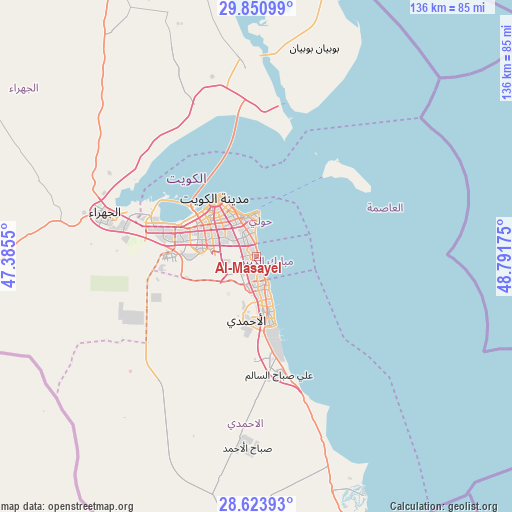
Al-Masayel GPS coordinates[2]
29° 14' 21.48" North, 48° 5' 19.032" East
| Map corner | latitude | longitude |
|---|---|---|
| Upper-left | 29.85099°, | 47.3855° |
| Center: | 29.2393°, | 48.08862° |
| Lower-right: | 28.62393°, | 48.79175° |
| Map W x H: | 136.4×136.4 km | = 84.8×84.8mi |
| max Lat: | 29.4425° ⇑56% North |
| Al-Masayel: | 29.2393° |
| min Lat: | ⇓44% South 28.63917° |
| min Long | Al-Masayel | max Long |
| 47.65806° | 48.08862° | 48.27472° |
| W 64%⇐ | ⇒36% E |
Elevation
Elevation of Al-Masayel is 7 m = 23 ft, and this is 19.7 m = 65 ft below average elevation for this country.
| Max E: |
164 m = 538 ft | 88% |
| Avg. | 26.7 m = 88 ft | |
| Al-Masayel | 7 m = 23 ft | |
Min E: |
4 m = 13 ft | 12% |
See also: Kuwait elevation on elevation.city.
Geographical zone
Al-Masayel is located in North temperate zone (between Tropic of Cancer and the Arctic Circle). Distance of this Northern Tropic circle is 645.2 km =400.9 mi to South.| Distance of | km | miles | from Al-Masayel |
|---|---|---|---|
| North Pole | 6756 | 4198 | to North |
| Arctic Circle | 4150.1 | 2578.8 | to North |
| Tropic Cancer | 645.2 | 400.9 | to South |
| Equator | 3251.1 | 2020.1 | to South |


Nearby cities:
15 places around Al-Masayel: (largest is in red/bold)
• Abu Al Hasaniya
5.9 km =3.7 mi,  155°
155°
• Abu Fatira
4.9 km =3 mi, 163°
• Al Farwānīyah
13.3 km =8.3 mi,  288°
288°
• Al Finţās
7.9 km =4.9 mi, 156°
• Al Funayţīs
2 km =1.2 mi,  140°
140°
• Al Mahbūlah
11.2 km =7 mi, 158°
• Ar Riqqah
10.4 km =6.5 mi,  176°
176°
• Ar Rumaythīyah
8.2 km =5.1 mi,  350°
350°
• As Sālimīyah
10.6 km =6.6 mi, 353°
• Bayān
8.1 km =5 mi,  331°
331°
• Janūb as Surrah
11.2 km =7 mi, 287°
• Mubārak al Kabīr
5.5 km =3.4 mi, 181°
• Salwá
6.4 km =4 mi, 351°
• Şabāḩ as Sālim
3.6 km =2.2 mi,  303°
303°
• Ḩawallī
11.9 km =7.4 mi, 330°
Sources, notices
• [Note1] Compared only with cities in Kuwait existing in our database
• [Src1] Map data: © OpenStreetMap contributors (CC-BY-SA)
• [Src2] Other city data from geonames.org with taken over terms of usage.
• [Src3] Geographical zone / Annual Mean Temperature by Robert A. Rohde @ Wikipedia
