Al Wafrah geodata
Al Wafrah (Al Aḩmadī) is a populated place; located in Kuwait in Asia/Kuwait (GMT+3) time zone. With population of 10,017 people, there are 19 cities with bigger population in this country. Compared to other cities in Kuwait, 100% of cities are located further ↑North; 96% of cities are located further →East and 100% of cities have lower elevation than Al Wafrah. Note1


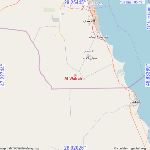
Al Wafrah GPS coordinates[2]
28° 38' 21.012" North, 47° 55' 50.016" East
| Map corner | latitude | longitude |
|---|---|---|
| Upper-left | 29.25445°, | 47.22744° |
| Center: | 28.63917°, | 47.93056° |
| Lower-right: | 28.02026°, | 48.63369° |
| Map W x H: | 137.2×137.2 km | = 85.3×85.3mi |
| max Lat: | 29.4425° ⇑100% North |
| Al Wafrah: | 28.63917° |
| min Lat: | ⇓0% South 28.63917° |
| min Long | Al Wafrah | max Long |
| 47.65806° | 47.93056° | 48.27472° |
| W 4%⇐ | ⇒96% E |
Elevation
Elevation of Al Wafrah is 164 m = 538 ft, and this is 137.3 m = 450 ft above average elevation for this country.
| Max E: |
164 m = 538 ft | 0% |
| Al Wafrah | 164 m 538 ft | |
| Avg. | 26.7 m = 88 ft | |
Min E: |
4 m = 13 ft | 100% |
See also: Kuwait elevation on elevation.city.
Geographical zone
Al Wafrah is located in North temperate zone (between Tropic of Cancer and the Arctic Circle). Distance of this Northern Tropic circle is 578.5 km =359.5 mi to South.| Distance of | km | miles | from Al Wafrah |
|---|---|---|---|
| North Pole | 6822.7 | 4239.4 | to North |
| Arctic Circle | 4216.8 | 2620.2 | to North |
| Tropic Cancer | 578.5 | 359.5 | to South |
| Equator | 3184.4 | 1978.7 | to South |


Nearby cities:
15 places around Al Wafrah: (largest is in red/bold)
• Abu Al Hasaniya
63.9 km =39.7 mi,  16°
16°
• Abu Fatira
64.3 km =40 mi, 15°
• Al Aḩmadī
50.9 km =31.6 mi, 17°
• Al Farwānīyah
71 km =44.1 mi,  2°
2°
• Al Faḩāḩīl
53 km =32.9 mi, 21°
• Al Finţās
62.3 km =38.7 mi, 17°
• Al Funayţīs
67.3 km =41.8 mi,  14°
14°
• Al Mahbūlah
59.5 km =37 mi, 19°
• Al Manqaf
54.5 km =33.9 mi, 21°
• Al-Masayel
68.5 km =42.6 mi, 12°
• Ar Riqqah
58.6 km =36.4 mi, 15°
• Ar Rābiyah
72.9 km =45.3 mi, 0°
• Janūb as Surrah
70.2 km =43.6 mi, 3°
• Mubārak al Kabīr
63.1 km =39.2 mi, 13°
• Şabāḩ as Sālim
69.8 km =43.4 mi, 10°
Sources, notices
• [Note1] Compared only with cities in Kuwait existing in our database
• [Src1] Map data: © OpenStreetMap contributors (CC-BY-SA)
• [Src2] Other city data from geonames.org with taken over terms of usage.
• [Src3] Geographical zone / Annual Mean Temperature by Robert A. Rohde @ Wikipedia
