Al Finţās geodata
Al Finţās (Al Aḩmadī) is a populated place; located in Kuwait in Asia/Kuwait (GMT+3) time zone. With population of 23,071 people, there are 14 cities with bigger population in this country. Compared to other cities in Kuwait, 76% of cities are located further ↑North; 84% of cities are located further ←West and 80% of cities have higher elevation than Al Finţās. Note1


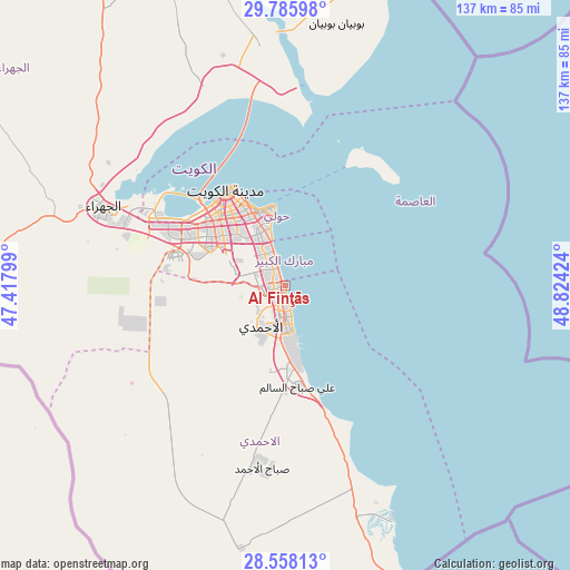
Al Finţās GPS coordinates[2]
29° 10' 26.004" North, 48° 7' 15.996" East
| Map corner | latitude | longitude |
|---|---|---|
| Upper-left | 29.78598°, | 47.41799° |
| Center: | 29.17389°, | 48.12111° |
| Lower-right: | 28.55813°, | 48.82424° |
| Map W x H: | 136.5×136.5 km | = 84.8×84.8mi |
| max Lat: | 29.4425° ⇑76% North |
| Al Finţās: | 29.17389° |
| min Lat: | ⇓24% South 28.63917° |
| min Long | Al Finţās | max Long |
| 47.65806° | 48.12111° | 48.27472° |
| W 84%⇐ | ⇒16% E |
Elevation
Elevation of Al Finţās is 8 m = 26 ft, and this is 18.7 m = 61 ft below average elevation for this country.
| Max E: |
164 m = 538 ft | 80% |
| Avg. | 26.7 m = 88 ft | |
| Al Finţās | 8 m = 26 ft | |
Min E: |
4 m = 13 ft | 20% |
See also: Kuwait elevation on elevation.city.
Geographical zone
Al Finţās is located in North temperate zone (between Tropic of Cancer and the Arctic Circle). Distance of this Northern Tropic circle is 637.9 km =396.4 mi to South.| Distance of | km | miles | from Al Finţās |
|---|---|---|---|
| North Pole | 6763.2 | 4202.5 | to North |
| Arctic Circle | 4157.3 | 2583.2 | to North |
| Tropic Cancer | 637.9 | 396.4 | to South |
| Equator | 3243.8 | 2015.6 | to South |


Nearby cities:
15 places around Al Finţās: (largest is in red/bold)
• Abu Al Hasaniya
2 km =1.2 mi,  338°
338°
• Abu Fatira
3.2 km =2 mi,  325°
325°
• Al Aḩmadī
11.4 km =7.1 mi,  198°
198°
• Al Faḩāḩīl
10.2 km =6.3 mi,  174°
174°
• Al Funayţīs
6 km =3.7 mi, 341°
• Al Mahbūlah
3.3 km =2.1 mi,  164°
164°
• Al Manqaf
8.7 km =5.4 mi, 172°
• Al-Masayel
7.9 km =4.9 mi, 336°
• Ar Riqqah
4 km =2.5 mi,  219°
219°
• Ar Rumaythīyah
16 km =9.9 mi, 343°
• Bayān
16 km =9.9 mi, 333°
• Janūb as Surrah
17.5 km =10.9 mi,  307°
307°
• Mubārak al Kabīr
3.7 km =2.3 mi,  298°
298°
• Salwá
14.2 km =8.8 mi, 343°
• Şabāḩ as Sālim
11.1 km =6.9 mi, 326°
Sources, notices
• [Note1] Compared only with cities in Kuwait existing in our database
• [Src1] Map data: © OpenStreetMap contributors (CC-BY-SA)
• [Src2] Other city data from geonames.org with taken over terms of usage.
• [Src3] Geographical zone / Annual Mean Temperature by Robert A. Rohde @ Wikipedia
