Vieux Fort geodata
Vieux Fort (Vieux-Fort) is a seat of a first-order administrative division; located in Saint Lucia in America/St_Lucia (GMT-4) time zone. With population of 4,574 people, there are 2 cities with bigger population in this country. Compared to other cities in Saint Lucia, 100% of cities are located further ↑North; 58.3% of cities are located further ←West and 83.3% of cities have lower elevation than Vieux Fort. Note1


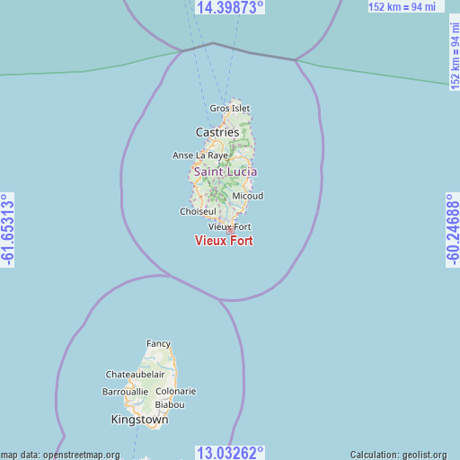
Vieux Fort GPS coordinates[2]
13° 43' 0.012" North, 60° 57' 0" West
| Map corner | latitude | longitude |
|---|---|---|
| Upper-left | 14.39873°, | -61.65313° |
| Center: | 13.71667°, | -60.95° |
| Lower-right: | 13.03262°, | -60.24688° |
| Map W x H: | 151.9×151.9 km | = 94.4×94.4mi |
| max Lat: | 14.09956° ⇑100% North |
| Vieux Fort: | 13.71667° |
| min Lat: | ⇓0% South 13.71667° |
| min Long | Vieux Fort | max Long |
| -61.06459° | -60.95° | -60.89132° |
| W 58.3%⇐ | ⇒41.7% E |
Elevation
Elevation of Vieux Fort is 76 m = 249 ft, and this is 34.4 m = 113 ft above average elevation for this country.
| Max E: |
119 m = 390 ft | 16.7% |
| Vieux Fort | 76 m 249 ft | |
| Avg. | 41.6 m = 136 ft | |
Min E: |
1 m = 3 ft | 83.3% |
See also: Saint Lucia elevation on elevation.city.
Geographical zone
Vieux Fort is located in North Torrid zone (between Equator and Tropic of Cancer). Distance of this Northern Tropic circle is 1080.8 km =671.6 mi to North.| Distance of | km | miles | from Vieux Fort |
|---|---|---|---|
| North Pole | 8481.9 | 5270.4 | to North |
| Arctic Circle | 5876 | 3651.2 | to North |
| Tropic Cancer | 1080.8 | 671.6 | to North |
| Equator | 1525.2 | 947.7 | to South |


Nearby cities:
12 places around Vieux Fort: (largest is in red/bold)
• Anse La Raye
27.3 km =17 mi,  339°
339°
• Bisee
34.3 km =21.3 mi,  355°
355°
• Canaries
24.1 km =15 mi,  329°
329°
• Cap Estate
42.6 km =26.5 mi,  0°
0°
• Castries
31.6 km =19.6 mi,  348°
348°
• Choiseul
12.4 km =7.7 mi,  300°
300°
• Dennery
22.8 km =14.2 mi,  16°
16°
• Gros Islet
38.9 km =24.2 mi, 0°
• Laborie
5.2 km =3.2 mi,  315°
315°
• Micoud
12.4 km =7.7 mi,  25°
25°
• Praslin
18.6 km =11.6 mi, 17°
• Soufrière
19.3 km =12 mi, 323°
Sources, notices
• [Note1] Compared only with cities in Saint Lucia existing in our database
• [Src1] Map data: © OpenStreetMap contributors (CC-BY-SA)
• [Src2] Other city data from geonames.org with taken over terms of usage.
• [Src3] Geographical zone / Annual Mean Temperature by Robert A. Rohde @ Wikipedia
