Castries geodata
Castries is a capital of a political entity; located in Saint Lucia in America/St_Lucia (GMT-4) time zone. With population of 20,000 people, there are 0 cities with bigger population in this country. Compared to other cities in Saint Lucia, 75% of cities are located further ↓South; 66.7% of cities are located further →East and 100% of cities have lower elevation than Castries. Note1


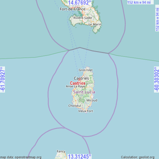
Castries GPS coordinates[2]
13° 59' 44.52" North, 61° 0' 22.104" West
| Map corner | latitude | longitude |
|---|---|---|
| Upper-left | 14.67692°, | -61.70927° |
| Center: | 13.9957°, | -61.00614° |
| Lower-right: | 13.31245°, | -60.30302° |
| Map W x H: | 151.7×151.7 km | = 94.3×94.3mi |
| max Lat: | 14.09956° ⇑25% North |
| Castries: | 13.9957° |
| min Lat: | ⇓75% South 13.71667° |
| min Long | Castries | max Long |
| -61.06459° | -61.00614° | -60.89132° |
| W 33.3%⇐ | ⇒66.7% E |
Elevation
Elevation of Castries is 119 m = 390 ft, and this is 77.4 m = 254 ft above average elevation for this country.
| Max E: |
119 m = 390 ft | 0% |
| Castries | 119 m 390 ft | |
| Avg. | 41.6 m = 136 ft | |
Min E: |
1 m = 3 ft | 100% |
See also: Saint Lucia elevation on elevation.city.
Geographical zone
Castries is located in North Torrid zone (between Equator and Tropic of Cancer). Distance of this Northern Tropic circle is 1049.7 km =652.3 mi to North.| Distance of | km | miles | from Castries |
|---|---|---|---|
| North Pole | 8450.9 | 5251.1 | to North |
| Arctic Circle | 5845 | 3631.9 | to North |
| Tropic Cancer | 1049.7 | 652.3 | to North |
| Equator | 1556.2 | 967 | to South |


Nearby cities:
12 places around Castries: (largest is in red/bold)
• Anse La Raye
6.5 km =4 mi,  212°
212°
• Bisee
4.7 km =2.9 mi,  47°
47°
• Canaries
12.2 km =7.6 mi, 211°
• Cap Estate
13.4 km =8.3 mi,  30°
30°
• Choiseul
25.2 km =15.7 mi,  190°
190°
• Dennery
15.4 km =9.6 mi,  126°
126°
• Gros Islet
9.9 km =6.2 mi,  37°
37°
• Laborie
27.4 km =17 mi,  174°
174°
• Micoud
23 km =14.3 mi,  150°
150°
• Praslin
17.8 km =11.1 mi,  138°
138°
• Soufrière
16.4 km =10.2 mi,  199°
199°
• Vieux Fort
31.6 km =19.6 mi, 168°
Sources, notices
• [Note1] Compared only with cities in Saint Lucia existing in our database
• [Src1] Map data: © OpenStreetMap contributors (CC-BY-SA)
• [Src2] Other city data from geonames.org with taken over terms of usage.
• [Src3] Geographical zone / Annual Mean Temperature by Robert A. Rohde @ Wikipedia
