Cap Estate geodata
Cap Estate (Gros-Islet) is a populated place; located in Saint Lucia in America/St_Lucia (GMT-4) time zone. With population of 677 people, there are 11 cities with bigger population in this country. Compared to other cities in Saint Lucia, 100% of cities are located further ↓South; 75% of cities are located further ←West and 66.7% of cities have lower elevation than Cap Estate. Note1


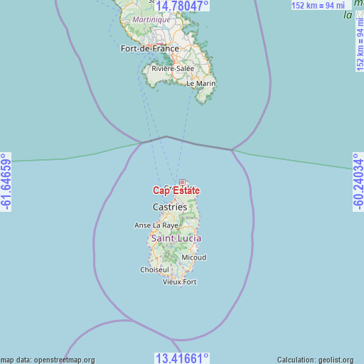
Cap Estate GPS coordinates[2]
14° 5' 58.416" North, 60° 56' 36.456" West
| Map corner | latitude | longitude |
|---|---|---|
| Upper-left | 14.78047°, | -61.64659° |
| Center: | 14.09956°, | -60.94346° |
| Lower-right: | 13.41661°, | -60.24034° |
| Map W x H: | 151.6×151.6 km | = 94.2×94.2mi |
| max Lat: | 14.09956° ⇑0% North |
| Cap Estate: | 14.09956° |
| min Lat: | ⇓100% South 13.71667° |
| min Long | Cap Estate | max Long |
| -61.06459° | -60.94346° | -60.89132° |
| W 75%⇐ | ⇒25% E |
Elevation
Elevation of Cap Estate is 51 m = 167 ft, and this is 9.4 m = 31 ft above average elevation for this country.
| Max E: |
119 m = 390 ft | 33.3% |
| Cap Estate | 51 m 167 ft | |
| Avg. | 41.6 m = 136 ft | |
Min E: |
1 m = 3 ft | 66.7% |
See also: Saint Lucia elevation on elevation.city.
Geographical zone
Cap Estate is located in North Torrid zone (between Equator and Tropic of Cancer). Distance of this Northern Tropic circle is 1038.2 km =645.1 mi to North.| Distance of | km | miles | from Cap Estate |
|---|---|---|---|
| North Pole | 8439.3 | 5243.9 | to North |
| Arctic Circle | 5833.4 | 3624.7 | to North |
| Tropic Cancer | 1038.2 | 645.1 | to North |
| Equator | 1567.7 | 974.1 | to South |


Nearby cities:
12 places around Cap Estate: (largest is in red/bold)
• Anse La Raye
19.9 km =12.4 mi,  211°
211°
• Bisee
9 km =5.6 mi,  201°
201°
• Canaries
25.5 km =15.8 mi, 210°
• Castries
13.4 km =8.3 mi, 210°
• Choiseul
38.1 km =23.7 mi, 197°
• Dennery
21.4 km =13.3 mi,  164°
164°
• Gros Islet
3.7 km =2.3 mi,  190°
190°
• Laborie
39.1 km =24.3 mi, 186°
• Micoud
31.8 km =19.8 mi,  171°
171°
• Praslin
25.4 km =15.8 mi, 168°
• Soufrière
29.7 km =18.5 mi, 204°
• Vieux Fort
42.6 km =26.5 mi,  180°
180°
Sources, notices
• [Note1] Compared only with cities in Saint Lucia existing in our database
• [Src1] Map data: © OpenStreetMap contributors (CC-BY-SA)
• [Src2] Other city data from geonames.org with taken over terms of usage.
• [Src3] Geographical zone / Annual Mean Temperature by Robert A. Rohde @ Wikipedia
