Triesen geodata
Triesen is a seat of a first-order administrative division; located in Liechtenstein in Europe/Vaduz (GMT+2) time zone. With population of 4,701 people, there are 2 cities with bigger population in this country. Compared to other cities in Liechtenstein, 90% of cities are located further ↑North; 60% of cities are located further ←West and 70% of cities have lower elevation than Triesen. Note1


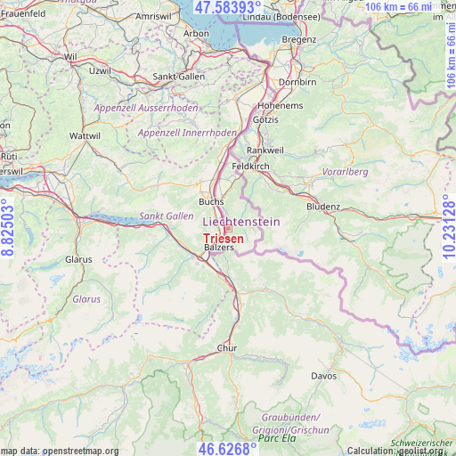
Triesen GPS coordinates[2]
47° 6' 27.072" North, 9° 31' 41.34" East
| Map corner | latitude | longitude |
|---|---|---|
| Upper-left | 47.58393°, | 8.82503° |
| Center: | 47.10752°, | 9.52815° |
| Lower-right: | 46.6268°, | 10.23128° |
| Map W x H: | 106.4×106.4 km | = 66.1×66.1mi |
| max Lat: | 47.23799° ⇑90% North |
| Triesen: | 47.10752° |
| min Lat: | ⇓10% South 47.06665° |
| min Long | Triesen | max Long |
| 9.50251° | 9.52815° | 9.54678° |
| W 60%⇐ | ⇒40% E |
Elevation
Elevation of Triesen is 500 m = 1640 ft, and this is 42.4 m = 139 ft below average elevation for this country.
| Max E: |
854 m = 2802 ft | 30% |
| Avg. | 542.4 m = 1780 ft | |
| Triesen | 500 m = 1640 ft | |
Min E: |
434 m = 1424 ft | 70% |
See also: Liechtenstein elevation on elevation.city.
Geographical zone
Triesen is located in North temperate zone (between Tropic of Cancer and the Arctic Circle). Distance of this North polar circle is 2163.3 km =1344.2 mi to North.| Distance of | km | miles | from Triesen |
|---|---|---|---|
| North Pole | 4769.2 | 2963.4 | to North |
| Arctic Circle | 2163.3 | 1344.2 | to North |
| Tropic Cancer | 2631.9 | 1635.4 | to South |
| Equator | 5237.9 | 3254.7 | to South |


Nearby cities:
10 places around Triesen: (largest is in red/bold)
• Balzers
4.9 km =3 mi,  203°
203°
• Eschen
11.5 km =7.1 mi,  357°
357°
• Gamprin
12.6 km =7.8 mi,  353°
353°
• Mauren
12.3 km =7.6 mi,  5°
5°
• Planken
8.7 km =5.4 mi, 8°
• Ruggell
14.5 km =9 mi, 359°
• Schaan
6.6 km =4.1 mi, 347°
• Schellenberg
13.8 km =8.6 mi, 5°
• Triesenberg
1.6 km =1 mi,  41°
41°
• Vaduz
3.8 km =2.4 mi, 352°
Sources, notices
• [Note1] Compared only with cities in Liechtenstein existing in our database
• [Src1] Map data: © OpenStreetMap contributors (CC-BY-SA)
• [Src2] Other city data from geonames.org with taken over terms of usage.
• [Src3] Geographical zone / Annual Mean Temperature by Robert A. Rohde @ Wikipedia
