Schaan geodata
Schaan is a seat of a first-order administrative division; located in Liechtenstein in Europe/Vaduz (GMT+2) time zone. With population of 5,748 people, there are 0 cities with bigger population in this country. Compared to other cities in Liechtenstein, 60% of cities are located further ↑North; 90% of cities are located further →East and 70% of cities have higher elevation than Schaan. Note1


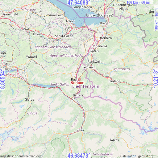
Schaan GPS coordinates[2]
47° 9' 53.928" North, 9° 30' 31.212" East
| Map corner | latitude | longitude |
|---|---|---|
| Upper-left | 47.64088°, | 8.80554° |
| Center: | 47.16498°, | 9.50867° |
| Lower-right: | 46.68478°, | 10.2118° |
| Map W x H: | 106.3×106.3 km | = 66.1×66.1mi |
| max Lat: | 47.23799° ⇑60% North |
| Schaan: | 47.16498° |
| min Lat: | ⇓40% South 47.06665° |
| min Long | Schaan | max Long |
| 9.50251° | 9.50867° | 9.54678° |
| W 10%⇐ | ⇒90% E |
Elevation
Elevation of Schaan is 453 m = 1486 ft, and this is 89.4 m = 293 ft below average elevation for this country.
| Max E: |
854 m = 2802 ft | 70% |
| Avg. | 542.4 m = 1780 ft | |
| Schaan | 453 m = 1486 ft | |
Min E: |
434 m = 1424 ft | 30% |
See also: Liechtenstein elevation on elevation.city.
Geographical zone
Schaan is located in North temperate zone (between Tropic of Cancer and the Arctic Circle). Distance of this North polar circle is 2156.9 km =1340.2 mi to North.| Distance of | km | miles | from Schaan |
|---|---|---|---|
| North Pole | 4762.8 | 2959.5 | to North |
| Arctic Circle | 2156.9 | 1340.2 | to North |
| Tropic Cancer | 2638.3 | 1639.4 | to South |
| Equator | 5244.3 | 3258.7 | to South |


Nearby cities:
10 places around Schaan: (largest is in red/bold)
• Balzers
10.9 km =6.8 mi,  182°
182°
• Eschen
5.2 km =3.2 mi,  11°
11°
• Gamprin
6.2 km =3.9 mi,  0°
0°
• Mauren
6.5 km =4 mi,  24°
24°
• Planken
3.5 km =2.2 mi,  50°
50°
• Ruggell
8.2 km =5.1 mi, 8°
• Schellenberg
7.9 km =4.9 mi, 21°
• Triesen
6.6 km =4.1 mi,  167°
167°
• Triesenberg
5.8 km =3.6 mi,  154°
154°
• Vaduz
2.8 km =1.7 mi,  159°
159°
Sources, notices
• [Note1] Compared only with cities in Liechtenstein existing in our database
• [Src1] Map data: © OpenStreetMap contributors (CC-BY-SA)
• [Src2] Other city data from geonames.org with taken over terms of usage.
• [Src3] Geographical zone / Annual Mean Temperature by Robert A. Rohde @ Wikipedia
