Varėna geodata
Varėna (Alytus) is a seat of a second-order administrative division; located in Lithuania in Europe/Vilnius (GMT+3) time zone. With population of 10,304 people, there are 50 cities with bigger population in this country. Compared to other cities in Lithuania, 97.8% of cities are located further ↑North; 67.2% of cities are located further ←West and 74.6% of cities have lower elevation than Varėna. Note1


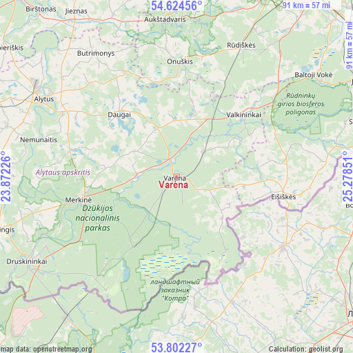
Varėna GPS coordinates[2]
54° 12' 55.656" North, 24° 34' 31.368" East
| Map corner | latitude | longitude |
|---|---|---|
| Upper-left | 54.62456°, | 23.87226° |
| Center: | 54.21546°, | 24.57538° |
| Lower-right: | 53.80227°, | 25.27851° |
| Map W x H: | 91.4×91.4 km | = 56.8×56.8mi |
| max Lat: | 56.36149° ⇑97.8% North |
| Varėna: | 54.21546° |
| min Lat: | ⇓2.2% South 54.01573° |
| min Long | Varėna | max Long |
| 20.99651° | 24.57538° | 26.43984° |
| W 67.2%⇐ | ⇒32.8% E |
Elevation
Elevation of Varėna is 128 m = 420 ft, and this is 37.3 m = 122 ft above average elevation for this country.
| Max E: |
204 m = 669 ft | 25.4% |
| Varėna | 128 m 420 ft | |
| Avg. | 90.7 m = 298 ft | |
Min E: |
-1 m = -3 ft | 74.6% |
See also: Lithuania elevation on elevation.city.
Geographical zone
Varėna is located in North temperate zone (between Tropic of Cancer and the Arctic Circle). Distance of this North polar circle is 1373 km =853.1 mi to North.| Distance of | km | miles | from Varėna |
|---|---|---|---|
| North Pole | 3978.9 | 2472.4 | to North |
| Arctic Circle | 1373 | 853.1 | to North |
| Tropic Cancer | 3422.3 | 2126.5 | to South |
| Equator | 6028.2 | 3745.7 | to South |


Nearby cities:
15 places around Varėna: (largest is in red/bold)
• Alytus
40.1 km =24.9 mi,  300°
300°
• Aukstadvaris
40.6 km =25.2 mi,  355°
355°
• Baltoji Vokė
58.5 km =36.4 mi,  43°
43°
• Birštonas
56 km =34.8 mi,  321°
321°
• Daugai
23 km =14.3 mi, 316°
• Druskininkai
44.3 km =27.5 mi,  239°
239°
• Eišiškės
27.9 km =17.3 mi,  99°
99°
• Grigiškės
61.5 km =38.2 mi,  32°
32°
• Jieznas
49.9 km =31 mi,  328°
328°
• Lentvaris
56.7 km =35.2 mi, 32°
• Rūdiškės
37.3 km =23.2 mi, 26°
• Senieji Trakai
51 km =31.7 mi, 30°
• Trakai
52.4 km =32.6 mi, 26°
• Veisiejai
58.6 km =36.4 mi,  257°
257°
• Šalčininkai
53.7 km =33.4 mi,  78°
78°
Sources, notices
• [Note1] Compared only with cities in Lithuania existing in our database
• [Src1] Map data: © OpenStreetMap contributors (CC-BY-SA)
• [Src2] Other city data from geonames.org with taken over terms of usage.
• [Src3] Geographical zone / Annual Mean Temperature by Robert A. Rohde @ Wikipedia
