Sabhā geodata
Sabhā is a seat of a first-order administrative division; located in Libya in Africa/Tripoli (GMT+2) time zone. With population of 130,000 people, there are 9 cities with bigger population in this country. Compared to other cities in Libya, 88.7% of cities are located further ↑North; 50.9% of cities are located further ←West and 77.4% of cities have lower elevation than Sabhā. Note1


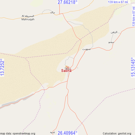
Sabhā GPS coordinates[2]
27° 2' 15.576" North, 14° 25' 41.952" East
| Map corner | latitude | longitude |
|---|---|---|
| Upper-left | 27.66218°, | 13.7252° |
| Center: | 27.03766°, | 14.42832° |
| Lower-right: | 26.40964°, | 15.13145° |
| Map W x H: | 139.3×139.3 km | = 86.6×86.6mi |
| max Lat: | 32.94699° ⇑88.7% North |
| Sabhā: | 27.03766° |
| min Lat: | ⇓11.3% South 24.1989° |
| min Long | Sabhā | max Long |
| 9.50072° | 14.42832° | 25.0866° |
| W 50.9%⇐ | ⇒49.1% E |
Elevation
Elevation of Sabhā is 421 m = 1381 ft, and this is 188.8 m = 619 ft above average elevation for this country.
| Max E: |
704 m = 2310 ft | 22.6% |
| Sabhā | 421 m 1381 ft | |
| Avg. | 232.2 m = 762 ft | |
Min E: |
3 m = 10 ft | 77.4% |
See also: Sabhā elevation on elevation.city.
Geographical zone
Sabhā is located in North temperate zone (between Tropic of Cancer and the Arctic Circle). Distance of this Northern Tropic circle is 400.4 km =248.8 mi to South.| Distance of | km | miles | from Sabhā |
|---|---|---|---|
| North Pole | 7000.8 | 4350.1 | to North |
| Arctic Circle | 4394.9 | 2730.9 | to North |
| Tropic Cancer | 400.4 | 248.8 | to South |
| Equator | 3006.3 | 1868 | to South |


Nearby cities:
8 places around Sabhā: (largest is in red/bold)
• Al Jadīd
3.1 km =1.9 mi,  296°
296°
• Al Qaţrūn
233 km =144.8 mi,  174°
174°
• Brak
59 km =36.7 mi,  344°
344°
• Hūn
276 km =171.5 mi,  32°
32°
• Idrī
143.5 km =89.2 mi,  288°
288°
• Murzuq
134.7 km =83.7 mi,  202°
202°
• Ubari
171.4 km =106.5 mi,  253°
253°
• Waddān
289.7 km =180 mi,  35°
35°
Sources, notices
• [Note1] Compared only with cities in Libya existing in our database
• [Src1] Map data: © OpenStreetMap contributors (CC-BY-SA)
• [Src2] Other city data from geonames.org with taken over terms of usage.
• [Src3] Geographical zone / Annual Mean Temperature by Robert A. Rohde @ Wikipedia
