Sîngera geodata
Sîngera (Chișinău Municipality) is a populated place; located in Moldova in Europe/Chisinau (GMT+3) time zone. With population of 7,200 people, there are 48 cities with bigger population in this country. Compared to other cities in Moldova, 61.6% of cities are located further ↑North; 71.2% of cities are located further ←West and 69.9% of cities have higher elevation than Sîngera. Note1


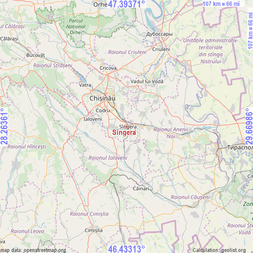
Sîngera GPS coordinates[2]
46° 54' 56.052" North, 28° 58' 0.228" East
| Map corner | latitude | longitude |
|---|---|---|
| Upper-left | 47.39371°, | 28.26361° |
| Center: | 46.91557°, | 28.96673° |
| Lower-right: | 46.43313°, | 29.66986° |
| Map W x H: | 106.8×106.8 km | = 66.4×66.4mi |
| max Lat: | 48.43285° ⇑61.6% North |
| Sîngera: | 46.91557° |
| min Lat: | ⇓38.4% South 45.48167° |
| min Long | Sîngera | max Long |
| 27.07787° | 28.96673° | 29.9617° |
| W 71.2%⇐ | ⇒28.8% E |
Elevation
Elevation of Sîngera is 50 m = 164 ft, and this is 42.8 m = 140 ft below average elevation for this country.
| Max E: |
241 m = 791 ft | 69.9% |
| Avg. | 92.8 m = 304 ft | |
| Sîngera | 50 m = 164 ft | |
Min E: |
11 m = 36 ft | 30.1% |
See also: Moldova elevation on elevation.city.
Geographical zone
Sîngera is located in North temperate zone (between Tropic of Cancer and the Arctic Circle). Distance of this North polar circle is 2184.7 km =1357.5 mi to North.| Distance of | km | miles | from Sîngera |
|---|---|---|---|
| North Pole | 4790.5 | 2976.7 | to North |
| Arctic Circle | 2184.7 | 1357.5 | to North |
| Tropic Cancer | 2610.6 | 1622.2 | to South |
| Equator | 5216.5 | 3241.4 | to South |


Nearby cities:
15 places around Sîngera: (largest is in red/bold)
• Anenii Noi
20.8 km =12.9 mi,  101°
101°
• Bender
39.9 km =24.8 mi, 103°
• Chisinau
13 km =8.1 mi,  320°
320°
• Ciorescu
24.6 km =15.3 mi,  346°
346°
• Cricova
26 km =16.2 mi,  342°
342°
• Criuleni
36.2 km =22.5 mi,  23°
23°
• Hryhoriopol
36.6 km =22.7 mi,  43°
43°
• Hînceşti
30.1 km =18.7 mi,  251°
251°
• Ialoveni
14.3 km =8.9 mi,  282°
282°
• Strășeni
37.1 km =23.1 mi,  312°
312°
• Stăuceni
21.5 km =13.4 mi, 339°
• Ustia
39.6 km =24.6 mi, 17°
• Vadul lui Vodă
21.1 km =13.1 mi, 23°
• Varniţa
38.4 km =23.9 mi, 98°
• Vatra
24.8 km =15.4 mi, 315°
Sources, notices
• [Note1] Compared only with cities in Moldova existing in our database
• [Src1] Map data: © OpenStreetMap contributors (CC-BY-SA)
• [Src2] Other city data from geonames.org with taken over terms of usage.
• [Src3] Geographical zone / Annual Mean Temperature by Robert A. Rohde @ Wikipedia
