Hryhoriopol geodata
Hryhoriopol (Transnistria) is a populated place; located in Moldova in Europe/Chisinau (GMT+3) time zone. With population of 9,456 people, there are 38 cities with bigger population in this country. Compared to other cities in Moldova, 52.1% of cities are located further ↓South; 83.6% of cities are located further ←West and 94.5% of cities have higher elevation than Hryhoriopol. Note1


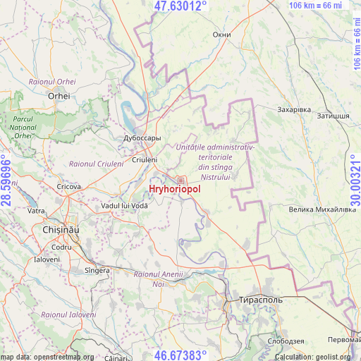
Hryhoriopol GPS coordinates[2]
47° 9' 14.868" North, 29° 18' 0.288" East
| Map corner | latitude | longitude |
|---|---|---|
| Upper-left | 47.63012°, | 28.59696° |
| Center: | 47.15413°, | 29.30008° |
| Lower-right: | 46.67383°, | 30.00321° |
| Map W x H: | 106.3×106.3 km | = 66.1×66.1mi |
| max Lat: | 48.43285° ⇑47.9% North |
| Hryhoriopol: | 47.15413° |
| min Lat: | ⇓52.1% South 45.48167° |
| min Long | Hryhoriopol | max Long |
| 27.07787° | 29.30008° | 29.9617° |
| W 83.6%⇐ | ⇒16.4% E |
Elevation
Elevation of Hryhoriopol is 21 m = 69 ft, and this is 71.8 m = 236 ft below average elevation for this country.
| Max E: |
241 m = 791 ft | 94.5% |
| Avg. | 92.8 m = 304 ft | |
| Hryhoriopol | 21 m = 69 ft | |
Min E: |
11 m = 36 ft | 5.5% |
See also: Moldova elevation on elevation.city.
Geographical zone
Hryhoriopol is located in North temperate zone (between Tropic of Cancer and the Arctic Circle). Distance of this North polar circle is 2158.1 km =1341 mi to North.| Distance of | km | miles | from Hryhoriopol |
|---|---|---|---|
| North Pole | 4764 | 2960.2 | to North |
| Arctic Circle | 2158.1 | 1341 | to North |
| Tropic Cancer | 2637.1 | 1638.6 | to South |
| Equator | 5243 | 3257.8 | to South |


Nearby cities:
15 places around Hryhoriopol: (largest is in red/bold)
• Anenii Noi
31.1 km =19.3 mi,  189°
189°
• Bender
38.3 km =23.8 mi,  159°
159°
• Chisinau
37.4 km =23.2 mi,  243°
243°
• Ciorescu
31.2 km =19.4 mi,  265°
265°
• Cocieri
21.4 km =13.3 mi,  319°
319°
• Cricova
33.2 km =20.6 mi, 266°
• Criuleni
12.5 km =7.8 mi,  301°
301°
• Dubăsari
16 km =9.9 mi, 320°
• Maiac
11.3 km =7 mi,  34°
34°
• Stăuceni
33.3 km =20.7 mi,  258°
258°
• Sîngera
36.6 km =22.7 mi,  223°
223°
• Tiraspolul Nou
39.9 km =24.8 mi, 155°
• Ustia
17.4 km =10.8 mi,  310°
310°
• Vadul lui Vodă
18.4 km =11.4 mi,  247°
247°
• Varniţa
34.4 km =21.4 mi, 158°
Sources, notices
• [Note1] Compared only with cities in Moldova existing in our database
• [Src1] Map data: © OpenStreetMap contributors (CC-BY-SA)
• [Src2] Other city data from geonames.org with taken over terms of usage.
• [Src3] Geographical zone / Annual Mean Temperature by Robert A. Rohde @ Wikipedia
