Prnjavor geodata
Prnjavor (Opština Plav) is a populated place; located in Montenegro in Europe/Podgorica (GMT+2) time zone. With population of 965 people, there are 37 cities with bigger population in this country. Compared to other cities in Montenegro, 71.4% of cities are located further ↓South; 96.8% of cities are located further ←West and 93.7% of cities have lower elevation than Prnjavor. Note1


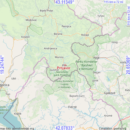
Prnjavor GPS coordinates[2]
42° 35' 53.016" North, 19° 57' 2.016" East
| Map corner | latitude | longitude |
|---|---|---|
| Upper-left | 43.11349°, | 19.24744° |
| Center: | 42.59806°, | 19.95056° |
| Lower-right: | 42.07833°, | 20.65369° |
| Map W x H: | 115.1×115.1 km | = 71.5×71.5mi |
| max Lat: | 43.38472° ⇑28.6% North |
| Prnjavor: | 42.59806° |
| min Lat: | ⇓71.4% South 41.92936° |
| min Long | Prnjavor | max Long |
| 18.50647° | 19.95056° | 20.16652° |
| W 96.8%⇐ | ⇒3.2% E |
Elevation
Elevation of Prnjavor is 976 m = 3202 ft, and this is 630 m = 2067 ft above average elevation for this country.
| Max E: |
1448 m = 4751 ft | 6.3% |
| Prnjavor | 976 m 3202 ft | |
| Avg. | 346 m = 1135 ft | |
Min E: |
4 m = 13 ft | 93.7% |
See also: Montenegro elevation on elevation.city.
Geographical zone
Prnjavor is located in North temperate zone (between Tropic of Cancer and the Arctic Circle). Distance of this Northern Tropic circle is 2130.5 km =1323.8 mi to South.| Distance of | km | miles | from Prnjavor |
|---|---|---|---|
| North Pole | 5270.6 | 3275 | to North |
| Arctic Circle | 2664.7 | 1655.8 | to North |
| Tropic Cancer | 2130.5 | 1323.8 | to South |
| Equator | 4736.5 | 2943.1 | to South |


Nearby cities:
15 places around Prnjavor: (largest is in red/bold)
• Andrijevica
19.9 km =12.4 mi,  319°
319°
• Berane
27.9 km =17.3 mi,  346°
346°
• Bijelo Polje
51.7 km =32.1 mi,  341°
341°
• Dinoša
54 km =33.6 mi,  248°
248°
• Gusinje
10.4 km =6.5 mi, 247°
• Kolašin
43.3 km =26.9 mi,  305°
305°
• Mojkovac
50.2 km =31.2 mi, 323°
• Petnjica
34.6 km =21.5 mi,  1°
1°
• Plav
0.4 km =0.2 mi, 253°
• Podgorica
58.9 km =36.6 mi, 252°
• Rožaje
31.5 km =19.6 mi,  34°
34°
• Spuž
62.6 km =38.9 mi,  261°
261°
• Stijena
57.4 km =35.7 mi, 261°
• Tuzi
57 km =35.4 mi,  243°
243°
• Vranj
61.5 km =38.2 mi, 240°
Sources, notices
• [Note1] Compared only with cities in Montenegro existing in our database
• [Src1] Map data: © OpenStreetMap contributors (CC-BY-SA)
• [Src2] Other city data from geonames.org with taken over terms of usage.
• [Src3] Geographical zone / Annual Mean Temperature by Robert A. Rohde @ Wikipedia
